
A Practical System for Integrating Earth Observation Data
SAEON submitted the following discussion document to the Department of Science and Technology following the approval of the South African Earth Observation Strategy by the South African Cabinet.
Created by Avinash Chuntharpursat & Johan C Pauw
This paper is aimed at promoting discussion on the institutionalised integration of Earth observation data in context of the South African Earth Observation Strategy (SAEOS) under the auspices of the Department of Science and Technology. The proposed system will connect to the Global Earth Observation System of Systems (GEOSS) to provide interconnectivity with international data providers and users.
1. Introduction
Currently Earth observation data sits at the various institutions that produce the data. The SAEOS initiative aims at connecting this data and making it publicly available at national and international levels.
In order to achieve this, a practical system needs to be implemented whereby data from different sources, using different standards can be seamlessly integrated. The South African Environmental Observation Network (SAEON, funded by the Department of Science and Technology) in a partnership with the CSIR (Natural Resources and Environment) and the Department of Minerals and Energy have been developing a collaborative GIS to achieve the above.
2. Tools for the Integration of data
SAEON is in the process of establishing a network of in situ observation nodes for the purpose of research, data gathering, data access, education, analysis and the sharing of knowledge and expertise in the public domain. However, SAEON is also an expanding network of organisations, inclusive of government departments and agencies, science councils, universities, conservation bodies and industrial companies. All of these must be connected electronically to SAEON. In order to achieve this, a system is proposed which is open source and open standards compliant and complies with the specification of the Open GIS Consortium, a non-profit, international, voluntary consensus standards organization that is leading the development of standards for geospatial and location based services.
The architecture for the Collaborative Geospatial Information System (CoGIS) is illustrated in Figure 1.
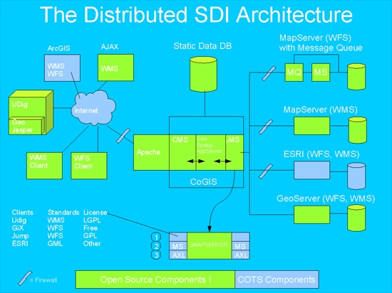
Figure 1: CoGIS Architecture. Illustrating the integration of data from different formats and providing and integrated product to the end user (provided by H.Jonck)
Figure 1 shows the integration of Web Map Service (WMS) and Web Feature Service (WFS) data via a central CoGIS (collaborative GIS) platform. The data can come from different services such as ESRI or GeoServer as long as the data is Open GIS compliant. Most major GIS software packages are Open GIS compliant.
Currently CoGIS is in the development phase with the core having recently been tested and peer reviewed. The work has been outsourced to an independent IT development company, previously involved with the SA-ISIS (South African Integrated Spatial Information System) and SABIF (South African Biodiversity Information Facility) projects.
The networking and data integrating functionality of CoGIS is a key to networking data from different organisations that are responsible for Earth observation in South Africa. In a low bandwidth environment such as South Africa, CoGIS aims to speed up access to data by using a system of caches whereby crucial datasets can be accessed from several different points. Researchers at different organisations can make their work in progress data accessible via the system and keep cached copies of each other's data for frequent referral. A central cache (Static Data Database, as depicted in Figure 1) can provide a central point of access to clean data.
In the proposed system for integrating EO data, technology has a major role to play. However, technology needs a support structure. There are organisational and human resource factors that play a crucial role in the establishment and sustainability of such an endeavour. These institutional requirements need to be considered.
3. Institutional requirements
Institutional requirements to be considered in the implementation of such a system include human resources, financial and technological. In operating as a network, strong liaison with other environmental data producing organisations is required. SAEON has been approached by several such organisations who wish to be part of this system (Appendix 1).
Human Resources required
- A technical steering committee is required to provide input into a data ethic and strategic guidance.
- A manager is required for the overall programme
- A technical data manager with GIS and other data management skills is required for managing the various databases.
- An analytical GIS specialist
- A specialist in interactive web deployment of GIS data.
The roles of the above people will be to manage the internal workings of the CoGIS as well as to liaise with external organisations that wish to join the system to bring their own systems in-line with the CoGIS.
Financial
The CoGIS is largely for the purposes of public good and is non-commercial in nature. Since it’s funded by the taxpayer, the public should generally enjoy full benefits free of charge, though the system will control access to certain sensitive datasets and will enforce intellectual property rights. The CoGIS will neither facilitate nor prohibit commercial transactions between data providers and users. The currency of CoGIS will exclusively be Earth observation data.
Technological
The CoGIS requires a high bandwidth and low latency environment. Currently, the CoGIS is being developed and housed at the Innovation Hub in Pretoria. The Innovation Hub environment does comply with the low latency requirement, but low bandwidth is ubiquitous in South Africa. CoGIS uses WFS technology and local data caches (databases) to circumvent South Africa’s low bandwidth environment.
4. Conclusion
A large number of local organisations with Earth observation data are interested in the data management system and CoGIS that SAEON is implementing. The system provides for the interoperability between distributed data holdings and users on their own terms. As such it is fully compliant with the requirements of the proposed SAEOS design and should be regarded as a prototype of the envisaged architecture.
We submit that the roll-out of SAEOS should be enhanced by CoGIS and that future developments within the SAEOS initiative should be coordinated such that any possible duplication of effort and investment is avoided.
5. References:
Barwell L, Hugo W, Jonck H, McFerren G, Chuntharpursat A & Naude
A, 2006. Connecting & Delivering SAEON data, information &
products: A proposed Service Oriented Architecture for SAEON. (in
prep.)
Open GIS Consortium: www.opengis.org
APPENDIX 1
LIST OF ORGANISATIONS THAT PROVIDED METADATASETS TO SAEON AND EXPRESSED INTEREST IN CONNECTING TO CoGIS
Agricultural Research Council
CSIR Natural Resources and Environment
SAIAB
Natal Museum
Iziko South African Museum
National Institute for Communicable Diseases
University of Pretoria
University of Cape Town
University of Kwazulu Natal
SANParks, Kruger National Park
CapeNature
BIOTA South
African Coelacanth Ecosystem Programme
ForestWood CC
Endangered Wildlife Trust
Department of Environmental Affairs and Tourism: Marine and Coastal
Management
KZN Department of Agriculture and Environmental Affairs
Statistics South Africa
LIST OF ORGANISATIONS WHO HAVE SIGNED AN ACCESSION OR NODE HOSTING AGREEMENT WITH SAEON OR HAS EXPRESSED THEIR INTENTION TO DO SO
South African National Parks
South African Institute for Aquatic Biodiversity
South African Biodiversity Institute
Water Research Commission
University of Stellenbosch
University of Cape Town
University of KwaZulu-Natal
University of Witwatersrand
CSIR (Natural Resources and the Environment)
Agricultural Research Council
MINTEK
Department of Environmental Affairs and Tourism
Department of Water Affairs and Forestry
Department of Minerals and Energy
Department of Provincial and Local Government
Development Bank of Southern Africa