
African Marine Atlas set to benefit a wide range of stakeholders
|
||
|
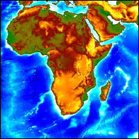
A definitive African Marine Atlas has just been launched. The Atlas was
developed by the Ocean Data and Information Network for Africa
(ODINAFRICA), with support from the Intergovernmental Oceanographic
Commission (IOC) of UNESCO and the Government of Flanders, Belgium.
Downloadable data products
The African Marine Atlas has over 800 downloadable data products
derived from the fields of marine geo-sphere, hydrosphere, atmosphere,
biosphere, geopolitical and the human socio-economic dimensions. It
provides substantial maps, 2007_April_Articles, data and information to
coastal resource managers, planners and decision-makers from various
administrative institutions and specialized agencies in Africa. The
Atlas will be of immense benefit to national institutions and a variety
of users such as environmentalists, local administrators, park
managers, the scientific community, fishing cooperatives, tourists,
hotel keepers, teachers, NGOs, the general public, and any other
interested persons.
The Atlas indicates areas of intense use along the coastline requiring
careful management, and provides potential foresight on likely
consequences of specific decisions. Further, the Atlas indicates gaps
in knowledge and information base, where additional efforts may be
directed. The Atlas will also act in other ways as a guide to
recreational opportunities and tourist attractions.
In developing the Atlas, the main objective was to collate available
geospatial datasets and information on the marine environment and to
summarize it into an African Marine Atlas suite. The website product is
one of a set of Marine Atlas products that will include web data
services, web mapping and an Atlas publication when completed.
International collaboration and partnerships
The Atlas was realized after nine months of intensive work by a team of 16 marine scientists and GIS experts from National Oceanographic Data Centres in Benin, Ghana, Kenya, Mauritania, Mauritius, Mozambique, Namibia, Senegal, Seychelles, South Africa, and Tanzania. International ocean data experts provided key inputs in data analysis. The Atlas is based on an extensive survey of coastal and marine data needs undertaken in early 2006 in all the countries participating in ODINAFRICA.
Primary partners in this project were the United Nations Environment Programme (UNEP), and the African Coelacanth Ecosystem Programme (ACEP). UNEP will develop a clearinghouse and information system on coastal and marine resources of Eastern Africa from the regional atlas.
The Atlas has brought great benefits to participating national institutions and Africa as a whole, by encouraging scientists to work together, learn new techniques, and build teams that will continue to update the Atlas regularly with national and local scale data sets.
The African Marine Atlas can be accessed at http://iodeweb2.vliz.be/omap/OMAP/index.htm