
SAEON helps to equip researchers to downscale climate change scenarios for South Africa
|
- By Dr Barend
F N Erasmus, School of Animal, Plant and Environmental
Science, University of the Witwatersrand
Climate change is becoming increasingly prominent on the global agenda, and there is a corresponding increase in the need to conduct realistic impacts and adaptation studies at global and local scales.
The main source of climate data of such studies is global circulation models (GCMs) and, to a lesser extent, regional climate models (RCMs). These are highly complex models that predict future climate change, given certain greenhouse gas emission scenarios. Although GCM data is freely available from the Intergovernmental Panel on Climate Change (www.ipcc.ch), there are two factors that have limited the widespread use of such data for local climate impact studies: the format and the spatial resolution of the data.
GCM data is typically in a text or binary grid format that is not easily compatible with Windows-based Geographic Information Systems (GIS) software. There has been an effort to address the data format issue: the most recent version of an industry-standard desktop GIS has a module to import netCDF files, which is a commonly used climate data format, and there is also one previous-generation GCM that has been transformed into a GIS format (available from www.gisclimatechange.org).
Advancing our understanding of likely impacts of climate change
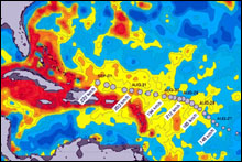
The spatial resolution of the data remains an issue: GCM data cells are typically in the order of 200 km by 300 km, and present an area-averaged prediction for each cell. Land-use planning operates at much finer scales. Indeed, it is only when we can relate observed and predicted global trends to locally measurable phenomena that we can advance our understanding of likely impacts of climate change on various sectors.
In South Africa, the Climate Systems Analysis Group (CSAG) at the University of Cape Town (led by Prof Bruce Hewitson) has capacity and expertise to generate GCM data. Prof Hewitson has also developed a technique to downscale the data in coarse GCM grid cells to smaller grid cells that are more useful to regional and local scale impacts studies.
Previous efforts to derive downscaled South African climate change data include the South African Country Studies on Climate Change and the Assessment of Impacts and Adaptation to Climate Change project. These efforts, although very useful, were once-off events focusing on specific aspects of climate change impact studies and the climate change data, although freely available, were not widely distributed.
Through the recently released Fourth Assessment Report (AR4) of the IPCC, a new generation of GCM data sets were made available online. These data provided the ideal opportunity to update previous climate change impacts assessments. However, the challenge of scale and data format issues once again reared its head.
Common interest in these issues brought Drs Barend Erasmus, Emma Archer (Wits Institute for the Study of the Environment, WiSE) and Mark Tadross (CSAG, UCT) together. A need was identified to downscale the most recent South African GCM data and distribute it in a user-friendly GIS format. SAEON was identified as the ideal vehicle for the proposed project, and agreed to fund the project. Additional funding from the Wits Institute for the Study of the Environment (WiSE) enabled the organizers to fully sponsor all workshop participants.
Empowering end-users to make informed decisions
The aim of the project was to distribute downscaled climate change data in a GIS format to a wider user community, and empower end-users to make informed decisions about the use of this data in climate change impact studies.
A one-day workshop on high-resolution climate change data for southern Africa was held by the Systems Analysis Group of Cape Town and the Wits Institute for the Study of the Environment (WiSE) on the Wits Campus on 27 March 2007. Altogether 22 representatives from 14 organisations (provincial and national conservation agencies, tertiary education institutions and government research agencies) attended the event to be trained in methods to downscale data, such as regional climate models and statistical techniques, and to recognise the unique merits and disadvantages of each.
The workshop consisted of formal presentations by Dr Mark Tadross on metadata and background to climate change data, and Dr Barend Erasmus on the use of these data in biodiversity impact studies. The focus of the afternoon session was more practical - participants derived projected climate change surfaces using a GIS. Feedback from participants suggested that the practical session should be extended in future versions of the workshop.
Data was distributed in CD format at the workshop and will soon be posted on the data distribution website of the Climate Systems Analysis Group at UCT. The data consisted of four precipitation-based variables at quarter degree resolution for six global circulation models (three models from the IPCC Third Assessment and three models from IPCC Fourth Assessment) covering South Africa, and nine climate variables for each of two regional climate models (MM5 and PRECIS) at half degree resolution, covering sub-Saharan Africa.
Baseline reference climate data
An existing historical climate data set for sub-Saharan Africa (http://www.cru.uea.ac.uk/cru/data/tmc.htm), representing monthly mean values for the period 1961 to 1990, was also included to be used as a baseline reference climate data set in the development of projected climate change surfaces.
It is envisaged that a data update will be released in the course of this month that will include temperature-based variables for the six GCMs. A software compatibility issue with some of the older GIS packages has also been identified by end-users from the workshop, and will be addressed in the update.
We are considering presenting a similar workshop at other venues, and developing a software tool to calculate projected climate surfaces automatically for a large number of datasets.
Anyone who is interested in this data set can access it (and other guidance material) at http://www.csag.uct.ac.za/ . You can also email Dr Barend Erasmus on (barend.erasmus@wits.ac.za) for more information.