
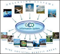
GEOSS: The Global Earth Observation System of Systems
|

To Understand Trends, Forecast Evolutions, and Inform
Decisions
- By Prof José Achache, Director, GEO Secretariat
GEO, the intergovernmental Group on Earth Observations, was established in 2005 to support the implementation of a Global Earth Observation System of Systems (GEOSS). The vision for this GEOSS is to realize a future wherein decisions and actions for the benefit of humankind are informed by coordinated, comprehensive and sustained Earth observations and information. Consistently, GEO has initiated a series of actions to improve monitoring of the state of the Earth, increase understanding of Earth processes, and enhance prediction of the behaviour of the Earth system.
Political decisions in the 21st century will have to take Earth sciences into account in order to evaluate the geological and environmental consequences. Evidence-based decision-making is fundamental to enhancing human health, safety and welfare; alleviating human suffering, including poverty; protecting the global environment; reducing disaster losses; and achieving sustainable development. Understanding the Earth system is a prerequisite for such informed decision-making. With the world population growing, industrial development accelerating and globalization increasing, we see more challenges ahead of us.
Climate change
Climate change is becoming a reality, bringing an increasing number of disasters like the hurricanes and floods which hit many countries severely. It is also changing the conditions for agriculture and water management. Invasive species are being transported several thousands of kilometres, creating havoc in their new habitat.
The consequences of these changes are reaching every country. Thus, local actions should be supported by global knowledge. GEO, the Group on Earth Observations was created for this purpose: to coordinate all the observing systems of the planet and to promote the sharing of the observation data and information products.
As a sustainable, comprehensive and coordinated observation "system of systems", GEOSS will work with and build upon existing national, regional, and international systems to provide comprehensive, coordinated Earth observations, transforming the data they collect into vital information for society.
GEOSS is driven by user needs, supports a broad range of implementation options, and is able to incorporate new technologies and methods. It builds on and adds value to existing Earth observation systems by coordinating their efforts, addressing critical gaps, supporting their interoperability, sharing information, reaching common understanding of user requirements, and improving delivery of information to users.
Data sharing
GEO will foster the sharing of observations across countries. Today, GEO includes 68 member countries, the European Commission and 46 participating organizations, among them South Africa. All contribute to the coordination of observations and will benefit from them.
GEO will foster the sharing of observations across disciplines and address cross-cutting issues. Because the Earth behaves as a system of systems interacting with each other, any single problem requires many different data and any single data will benefit many users.
Hence, GEO addresses nine Societal Benefit Areas: Disasters, Health, Energy, Climate, Water, Weather, Ecosystems, Agriculture and Biodiversity. The rationale for taking a cross-cutting approach in building GEOSS is guided by the potential for synergies. Indeed, many observations are relevant to different societal benefit areas. At the same time, most societal benefit areas are interdependent. Weather and climate changing patterns, for instance, have important implications for many areas, including human health, water availability, food security, and energy management.
GEO advocates data sharing principles that favour free and open exchange of data, in particular in support of developing countries and for research. GEOSS will help to ensure the quality data required by users reaches them in a timely fashion and in an appropriate format. There will be full and open exchange of data, metadata, and products shared within GEOSS, recognizing relevant international instruments and national policies and legislation.
Building GEOSS will require the development of scientific research and will stimulate the development of operational products, services and tools. It will, in particular, facilitate the transition from research to operational use and technology transfer of advanced systems to developing countries. Scientific research is crucial to optimize the use of GEOSS observations, and generate new applications in existing and emerging fields. Moreover achieving the GEO objectives will require:
1. Improving our understanding of basic Earth processes in and across all societal benefit areas.
2. Connecting scientific communities to
(i) facilitate access to, and eventually assimilation of, any
relevant data whether in-situ, airborne or space;
(ii) encourage the development of coupled models and Earth system
models; and
(iii) expand the use of specific methodologies to other disciplines,
e.g. "reverse tracing of precursors" also known as "pattern
recognition" from earthquake prediction to epidemiology.
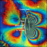
3. Developing new observation methodologies such as radar altimetry, Doppler lidar wind measurements and Synthetic Aperture Radar (SAR) Interferometry.
4. Linking existing methodologies to end-user applications such as multi-model ensemble weather and climate predictions to predictions of crop yield and malaria incidence.
5. Adapting to new processing technologies such as distributed grid-computing and remote processing using Web services.
Efforts in the foregoing areas will be supported by GEO activities to engage with the global scientific research and technological community. GEO will work to form linkages to major scientific research enterprises in each societal benefit area, and to ensure that relevant scientists and technical experts are involved and contributing to GEOSS in a truly participatory and meaningful way.
Building capacity
Finally, GEO will facilitate substantial capacity building efforts in human resources, institutions and observational infrastructures, particularly in developing countries. Special attention will be devoted to the development of systems to facilitate information collection and dissemination (GEONETCast, GEO Web Portal, GEO Clearinghouse).
By all means, evidence-based decision-making is becoming more critical than ever to sustainable development. Governments will need it. GEO will support it.