
SAEON safeguards 80 years of long-term observation records
|
SAEON has entered into an agreement with the Council for Scientific and
Industrial Research (CSIR) to maintain 80 years of long-term
streamflow, rainfall, water quality and climate records at Jonkershoek
Research Centre in the Western Cape.
The agreement, signed by Johan Pauw, Head of SAEON and Dr Pat Manders, Acting Director: Natural Resources and the Environment of the CSIR, contracts the CSIR to maintain monitoring of the Jonkershoek experimental catchment network and long-term climate monitoring until March 2008, when it is expected that the Department of Water Affairs and Forestry (DWAF) will resume its support for the observation system. SAEON will thus be ensuring that an extremely valuable long-term database remains uninterrupted.
In terms of the agreement, the CSIR will be responsible for maintaining the research infrastructure, the existing data base and electronic data processing. The CSIR will also be required to make the database available for general access by researchers nationally.
Early history
Jonkershoek Valley was first occupied by settlers when Simon van der Stel granted a number of freeholds in 1692. One freehold was granted to Jan Andriessen who had been a bachelor midshipman in the service of Dutch India Company and was known as Jan de Jonkheer (Jonker). He set up home in this exquisite valley about 65 km from the Cape of Good Hope castle. With time the area became known as the "The Valley Jonkershoek".
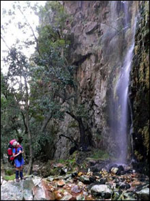
The valley is tucked away in the Boland mountains between Banhoek, Somerset West, Grabouw and Stellenbosch, which it seeps into. Racing through the valley is a stream, the source of the Eerste River - the first river encountered by early Dutch settlers after leaving Cape Town.
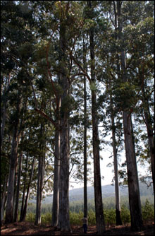
By the 1850s European settlers were over-exploiting South Africa's indigenous forest resources for timber, not only in Jonkershoek, but throughout colonised territory. As a result of rising concerns, authorities began a programme of afforestation (usually a grassland or fynbos conversion) using exotic species, particularly pines, eucalypts and some acacias.
But by the 1900s, following numerous complaints by farmers, it had become abundantly clear that these plantations were affecting stream flow. Presentations at the 1935 Fourth Empire Forestry Conference held in Cape Town resulted in a programme of research into "the influences of forests on water conservation and allied problems".
By 1936 construction was underway on weirs in the Jonkershoek State Forest and a research programme was developed, with Dr CL Wicht as founder and research director of the Jonkershoek Forestry Research Centre.
Proud research record
In 1938 the South African government started a network of hydrological experiments at Jonkershoek for the purpose of researching the impacts of afforestation on water supplies. Similar research stations were subsequently set up in the Drakensberg, Mpumalanga and Tzaneen, but these have since been closed due to a lack of government funding.
The experimental design was based on the classic paired-catchment principle used at Emmental in Switzerland and Wagon Wheel Gap, Colorado, USA. The principle of this approach is that the streamflow from two untreated catchments is compared, so as to establish their natural relationship. One is then planted to trees. The change in the relationship between the two catchments after afforestation could then be ascribed to the treatment or influences of afforestation.
Twenty-nine rain gauges, of which 12 were continuously recording, measured what water was going into the catchments and eight continuously-recording weirs (six remain operational) measured what was coming out.
The onset of streamflow reductions was evident at ~5 years, and is strongly associated with plantation age, up to a peak reduction occurring at ~15 years, followed by a gentle decline in water use. A rule of thumb is 30-40 mm streamflow reduction per 10% of catchment planted, at peak water use.
In a nutshell, the results of the research show that the onset of detectable streamflow reduction in the Jonkershoek catchments planted to pine occurs from around age five, peaks at around 15 years, followed by a slow decline in water use.
Key players
In those early years the research programme and catchments were managed by the then Department of Forestry through the South African Forestry Research Institute (SAFRI). When SAFRI was incorporated into the CSIR, the responsibility for maintaining these studies remained with the Department of Water Affairs and Forestry (DWAF), but was contracted out to CSIR.
Recognising the value of these catchments for maintaining long-term climatic and hydrological records, as well as the potential for future research on climate change and water resources, DWAF entered into a long-term contract with the CSIR in 1995 to support some of these experiments.
But in 2004, the Forestry Branch of DWAF indicated that support for these catchments was no longer in line with their strategy and mandate and that they wanted to terminate their funding of the project. One of the research groups in the CSIR has been carrying the costs of these catchments from overheads (no funding) for the past two years whilst negotiating for funding from DWAF, but is no longer able to do so.
DWAF recently indicated that they are considering taking over the monitoring pending the results of a thorough inspection of all the instruments and structures, and obtaining additional budget for this purpose. This process may, however, take more than a year.
As this may have caused a one-year gap in the previously perfectly maintained continuous climate and streamflow records, SAEON stepped in to support the programme.
"The project has several benefits," says Johan Pauw in support of SAEON's decision to fund the project in the interim. "It has unparalled data sets, given their length and continuity."
Climate change
The research has significant benefits, and the need for on-going research is needed now more than ever, given the growing threats of climate change. In terms of climate change alone research at Jonkershoek has yielded some interesting findings.
Whereas the National Water Resources Strategy notes that there is little conclusive evidence of accelerated large-scale and persistent long-term climate shifts in South Africa, ongoing research at Jonkershoek shows otherwise.
Data from some of the experiments conducted here show alarming downward trends in rainfall and runoff in the Western Cape mountains. There has been a decline of 14% (a loss of 55 mm) in some high-altitude rain gauges at Jonkershoek over 55 years from 1945 onwards, with a 20% reduction in mean runoff (a loss of nearly 500 mm).
Although the CSIR's involvement with these high-altitude rain gauges came to an end in the late 1990s, they managed to obtain the figures for the rain gauges on a regular basis from Cape Nature Conservation researchers, who are conducting their own measurements.
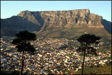
The Jonkershoek monitoring sites are directly adjacent to the new Berg River Water Scheme. These trends, if proven correct, have significant negative implications for the sustainability of water supplies to Cape Town.
Further monitoring and research is essential for national water resource management and security. Although projections of the impacts of climate change in Southern Africa have indicated a trend of decreased runoff, none have been of this magnitude.
"We need research catchments to track these changes," says CSIR researcher Arthur Chapman.
Water resource management
South African forest hydrology experiments are world renowned and are still cited in the international scientific literature. The research has provided a basis for DWAF's Stream-flow Reduction Activities (SFRA) policy and Working for Water programme, has impacted on legislation related to SFRA's and riparian zone management, and has led to the controversial water use charges imposed on plantation growers.
Riparian zone delineation is another consequence of the research findings, as trees growing in this zone use significantly more water than trees planted further up the slope. Other work included the impact of acid rain on nutrient loss from afforested catchments.
"The commercial forest industry today derives benefits in export markets from Forest Stewardship Council (FSC) certification that the industry is able to achieve, in part because of previous catchment research and implementation of research findings imposed on the industry," Chapman said.
International impact
South African forest hydrological and ecological experiments are world renowned. Some key papers from South African research efforts are cited extensively in international science literature. To date, more than 400 papers and conference proceedings have been produced using data collected within the Jonkershoek catchments.
These experimental catchments form the basis of several existing research projects and have excellent potential for future studies on catchment hydrological and ecological processes. The Streamflow Reduction Allocations (SFRA) policy and Working for Water Programme that emanated from these experiments are now used worldwide.
The Jonkershoek catchment experimental network in particular is known throughout the world as the monitoring sites with the longest uninterrupted hydrometeorological records of their kind in South Africa. This data record is invaluable for climate change studies and for verification of climate change modelling.
The commercial forest industry today derives benefits in export markets from Forest Stewardship Council (FSC) certification that the industry is able to achieve, in part because of previous catchment research and implementation of research findings imposed on the industry.
The research has led to legislation relating to SFRAs, and the allocation of water to rain-fed land-use activities. Another outcome is models such as "Gush Tables" used for forest water-use pricing, and policies that control land-use practices in mountain catchments, including the location of plantation forestry and the use of fire for vegetation management and conservation.
Benchmarks
These experiments provided benchmarks for validating a variety of hydrological models used for water resource management in South Africa.
The outcomes have all supported sustainable development in South Africa, allowing policy directives in the National Water Act and the Fire Act to be chosen with less associated risk.
It is a great example of an environmental observation system delivering environmental and societal benefits, where the results of long-term observations have been used for policy formulation and land-use regulation, which have led to greater sustainability of water resource availability in South Africa.