
CSIR to implement South Africa's Earth observation framework
|
Implementation of the South African Earth Observation Strategy (SAEOS)
has been delegated to the CSIR Satellite Applications Centre by the
Department of Science and Technology. This was announced by the
Minister of Science and Technology, Mr Mosibudi Mangena, at the recent
GEO Summit held in Cape Town on 28-30 November 2007.
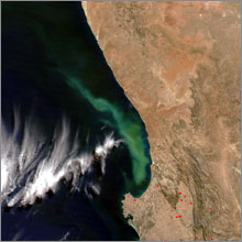
SAEOS, which provides guidance on national earth observation infrastructure, is South Africa's response to GEO's Global Earth Observation System of Systems (GEOSS) 10-year implementation plan. The GEOSS plan aims to establish a comprehensive, global monitoring system for end-users to access a vast quantity of near-real-time information on changes in the earth's land, oceans, atmosphere and biosphere via a single web portal.
The CSIR's Dr Corné Eloff explains how SAEOS will shape plans for South Africa's earth observation infrastructure. He heads the CSIR earth observation data centre (EODC) where the first phase of the infrastructure has been put in place. "Current EODC architecture comprises both state-of-the-art hardware and software for significant storage capacity and fast data extraction for image processing. The storage capacity will consist of a 120 Tb SAN and a robotics library to an expandable size of 1 Peta byte. Phase 2 will address advance archive management; the goal is to be able to supply high turnaround times for a multi-sensor portfolio of products up to orthorectified level by May 2008."
The EODC produces fully automated remote sensing supply chains. Eloff continues, "The CSIR has developed an automated processing system called SARMES (South African Resource Management and Expert System). This allows us to create fully automated processing chains to automate all steps from raw data ingestion to the packaging of a final orthorectified mosaic in a user-defined format." To orthorectify means to place and correct an image according to the earth's surface topology.
The value of the SARMES system becomes apparent when the advantage of automated feature extraction is added to it through the implementation of algorithms through the Definiens system architecture, using eCognition software. These features include forest layers, road layers and dwelling structures. The EODC's temporal dataset, dated since 1972, can be used for analysis and detection of land cover change over time. The extraction of specific national land cover layers and the automation of these processes are under investigation and seem promising for the future.
Complementing the earth observation (EO) portal is the second focus point for SAEOS. In the South African Environmental Observation Network (SAEON) programme such a web interface has been developed and will be used as a starting point to ensure connectivity to all other relevant geo-information custodians. SAEON establishes and maintains nodes linked by an information management network to serve as observation, research and education platforms for long-term studies of ecosystems. However, the EO portal will provide access to sources of spatial information owned by a number of custodians in South Africa such as vectors, aerial photographs and in-situ sensor information. As interoperability of data is vital for the best results, it is envisioned that the Meraka Institute's ICT for earth observation research group will play a role through creating and managing so-called middleware for the requisite interface between observing systems and application areas.
The ultimate goal of SAEOS is to contribute to the nine societal benefit areas identified by GEO, directly or indirectly: monitoring and assessment of natural disasters, health, energy, climate change, water, weather, ecosystems, agriculture and biodiversity.
Eloff sees SAEOS as a positive contribution to GEOSS and a flagship project for South Africa, "We are confident that the implementation of SAEOS will establish South Africa as one of the leading players in the African space arena, along with Algeria, Kenya and Nigeria."
This article first appeared in the December issue of CSIR eNews. It is reprinted with kind permission from the CSIR.
Related content
GEO Ministerial Summit places Earth observation science firmly on international radar screen