
Exploring the South-West Indian Ocean (Agulhas and Somali Current Large Marine Ecosystem – ASCLME – Project)
|
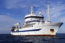
I was fortunate enough to have been afforded the opportunity to participate in two of the ASCLME Project research cruises on-board the Norwegian vessel R/V Dr. Fridtjof Nansen to the South-West Indian Ocean.
For those readers who have never participated in a research cruise, don’t let the word “cruise” mislead you into believing that this was some sort of holiday. On the contrary, a “research cruise” to any part of the world’s oceans is typically anything but!
Legs 2 and 3 of the cruise conducted research around the island of Mauritius and over the Mascarene Plateau respectively. Mauritius was chosen to represent an example of an island that is influenced by the South Equatorial Current system in the South-West Indian Ocean. The primary aim of Leg 2 (Mauritius survey) was to determine how the South Equatorial Current system influences the island’s Exclusive Economic Zone and its ecosystem.
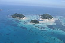
The Mascarene Plateau is a 2200 km crescent-shaped ridge extending between Mauritius in the south and the Seychelles in the north, arching back south again towards Madagascar. The Mascarene Plateau consists of various islands, banks and shoals that form a barrier to the westward moving South Equatorial Current. With little research being conducted on the Mascarene Plateau, this region represents a largely unexplored marine ecosystem.
The aim of Leg 3 was to conduct a detailed multi-disciplinary survey with focused attention on those regions that were most likely to be important for the management of resources and the ecosystem as a whole.
Probing marine ecosystems
The scientific crew on both legs consisted of a variety of nationalities: South African, Mauritian, Seychellois, French, Norwegian, Canadian, German and British, presenting an excellent opportunity to establish collaborations and international contacts.
Our research on the Mauritius leg started off with a bang about an hour after we had sailed out of Port Louis, the capital of Mauritius and main port. The majority of the scientific team were still trying to find their sea legs, many of them having never been to sea before. After the first few stations, which were about an hour’s steaming apart, the team began to work more like a well-oiled machine.
Typically, on a research cruise, the scientific team is divided into two groups which will operate on shifts, either 6-hourly or 12-hourly, depending on the chief scientist. During both the Mauritius and Mascarene Plateau cruises, we worked on 6-hourly cycles. I was on the grave-yard shift – midnight till 6am and then midday till 6pm … easy enough.
Though as the days wear on and start to melt into one another the serious lack of any decent sleep reduces one to a state rather near how I would imagine insanity to feel. The phone call to your cabin in the middle of the night wakes you up with a start, and a groan, “…the CTDs up!” What, already, I’ve only just fallen asleep!?
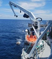
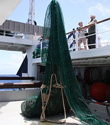
We’re on station and the CTD, or Conductivity Temperature Depth probe, has already been down to 4000m and is about to be hoisted into the wet lab so that we can fill our bottles with the waters from the deep.
In the dark, trying not to wake up fellow cabin mates, I dress and rush out into the passage running up flights of stairs to the lab deck where I find the CTD blinking in the bright light, seawater dripping off her. From the looks on my co-workers’ faces, they too are experiencing sleep deprivation and we all look a bit like starved zombies.
Within minutes life starts to find its way back, music is played from laptops and we move rather rapidly from dead-tired to busy scientists trying to understand how our oceans function. The samples we are collecting vary from seawater samples for chemical analysis (looking at variables like oxygen, salinity and nutrients) and phytoplankton biomass to net trawls that catch animals ranging from the tiny zooplankton to large fish.
The purpose behind all of this is to gain a better understanding of how the waters of the South-West Indian Ocean function, particularly those influenced largely by the Agulhas and Somali Currents or those that influence the productivity and marine resources of the East African countries and islands.
This is all part of a United Nations Development Programme (UNDP) project called the Agulhas and Somali Current Large Marine Ecosystem (ASCLME) project. Funded by the Global Environmental Fund (GEF), the project aims to improve the management of waters and resources that are co-governed for this particular stretch of coastline.
Shared marine ecosystems
Although, to a degree some coastal resources are localised, to a large extent coastal and oceanic resources do not follow national boundaries and a cooperative approach between governments to the management and conservation of these resources is essential. The Large Marine Ecosystem projects, of which there are many (including the Benguela Current Large Marine Ecosystem [BCLME] project), aim to first gain sufficient information on the structure and functioning of shared marine ecosystems, including the resource uses and requirements of the nations involved, producing a Transboundary Diagnostic Analysis. The second phase of an LME project is to produce inter-governmental management guidelines in the form of a Strategic Action Plan.
The ASCLME project is in its second year of operation. During 2008, research cruises were conducted around Madagascar, to Mauritius, the Mascarene Plateau and through the Mozambique Channel.
This year, 2009, will see cruises conducted in the East Africa Current (off Kenya and Tanzania), the Comoros Basin and various South West Indian Ocean seamounts, as well as a cruise to deploy and service moorings to the east of Madagascar.
African Coelacanth Ecosystem Programme
In addition, the African Coelacanth Ecosystem Programme (ACEP) Phase II will be conducting research cruises to the Agulhas Bank and the Natal Bight. ACEP Phase II represents South Africa’s primary contribution to the ASCLME Project, focusing on research on the Agulhas Current in South Africa.
The South-West Indian Ocean directly impacts on South Africa’s coastal environment and weather patterns, but is relatively unexplored. For this reason, both the Elwandle and Egagasini Nodes of SAEON are key partners in ASCLME and ACEP and aim to contribute to the collection of baseline data for the region, against which climate and global change can be measured.
To find out more about ASCLME and ACEP ll have a look at their websites at www.asclme.org and http://www.saiab.ac.za/index.php?pid=36 respectively.