
We need YOUR help to define and classify land use
|
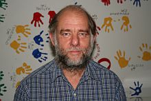
- Prof Tim O’ Connor, Observation Science Specialist, SAEON
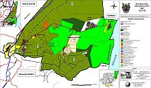
The Chief Directorate of Surveys and Mapping of the Department of Land Affairs has initiated work on developing a methodology for land use mapping.
The mapping is intended to complement the nearly completed initiative on developing a methodology for land cover mapping.
What is the difference between the two and why is this short announcement published in SAEON eNews?
Land cover refers to the natural or man-made features that cover an immediate area of the earth’s surface, while land use is the associated human activity. There can be only one land cover at a point in time whereas a specific parcel of land may experience multiple land uses, although there is usually only one primary land use and a land use is usually conducted in a context of legal and administrative requirements.
The Chief Directorate has appointed a service provider to determine user needs, derive a national land use classification, determine standards and specifications for land use mapping, and determine a classification methodology.
National workshops
To this end the service providers are in the process of holding workshops across the country, one of which I attended.
Two important points were realised from the presentations offered at the workshop. The first is that town planners have enjoyed a long history of classification and mapping of land use within the urban environment, as shown by the widespread use of LUMS in municipal planning.
By contrast, the larger part of the country’s surface in rural areas has not benefited to nearly the same degree – there is as yet no formal approach for these areas. There is some preliminary development from an agricultural perspective but very little evidence of defining or classifying land use from an environmental viewpoint.
The second point is that there is insufficient representation of people with an environmental interest at such workshops, perhaps because the term ‘mapping’ tends to attract those familiar with terms like SPOT5, polygon, and georectified. But the mapping cannot succeed unless its conceptual basis is sound. A conceptual basis for each of the main user groups needs to be accommodated.
Land use is one of the key anthropogenic impacts to be considered by SAEON. A sound mapping product of land use is required for their purposes. It is therefore opportune to solicit the input of interested parties into working toward a framework for land use that would serve environmental needs.
Interested parties should contact Tim O’Connor at timoconnor@xsinet.co.za