

Impacts of the oceans on climate
|
| This is the first in a series of articles on Southern African oceanography, written by Dr Juliet Hermes, Manager of the SAEON Egagasini Node for Marine Offshore Systems. The articles aim to give an overview of what is currently known about the key oceanographic features around Southern Africa. In this introductory article, the Agulhas Current is explored. |
South Africa is bounded by the South Indian Ocean on the east coast, the South Atlantic on the west coast and the Southern Ocean to the south.
There are many scientific papers that have been published on the key features of these oceans, as well as at least three definitive books –
- “The Agulhas Current” by J. R. E. Lutjeharms;
- “Benguela: Predicting a large marine ecosystem”, edited by V. Shannon et al.; and
- “The Prince Edward Islands. Land-sea Interactions in a Changing Ecosystem”, edited by S. Chown et al.
These three oceans play a vital role in determining Southern Africa’s local climate and weather patterns as well as being key drivers of the global climate. The key oceanographic features of these oceans will be explored in future articles. This month’s article will look at the east coast of southern Africa, with a particular focus on the Agulhas Current.
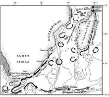
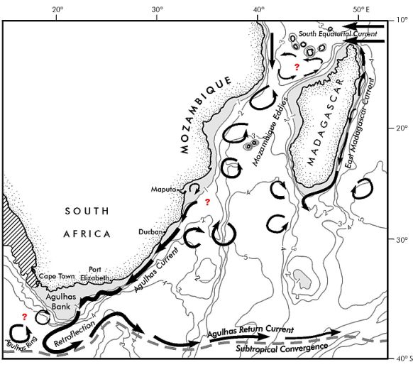
The schematic from Lutjeharms (Figure 1) gives an idea of the currents in the South-West Indian Ocean. The Agulhas current travels down the east coast of South Africa as an intense, well-defined western boundary current carrying, on average, anything between 60-70 Sverdrups (approximately 60 million bathtubs per second) of warm, salty water. Western boundary current is an oceanographic term referring to currents on the western edge of the major ocean gyres, in other words, flowing down the eastern coast of the respective land masses.
As illustrated in Figure 1, the Kwazulu-Natal coastline is characterised by a narrow shelf, down the edge of which the Agulhas Current travels, but as the current approaches Port Elizabeth, the bathymetry1 changes and the shelf extends. This broad shelf area off the south coast is known as the Agulhas Bank. It is as the shelf broadens that the Agulhas current becomes unstable and begins to meander (see Figure 1).
As this warm meandering current approaches the cool Atlantic waters it turns back on itself and heads back into the South-West Indian Ocean. This ‘turn around’ feature is termed the ‘Agulhas retroflection’, and the current at this stage is referred to as the Agulhas Return Current.
Approximately three to six times a year there is a large ‘short circuit’ in the retroflection region and huge ‘rings’ of warm Agulhas water, referred to as Agulhas rings or eddies, break off the retroflection and head into the South Atlantic Ocean. These rings carry large amounts of heat and salt into the cooler waters of the South Atlantic.
As oceanographers, we are only now beginning to understand the cause and frequency of this important ring shedding. The significance of these rings to global heat transferral and thus global climate will be discussed in a later article on global thermohaline circulation. Readers can also watch the movie ‘The Day After Tommorrow’ or Al Gore’s ‘Inconvenient Truth’ for an explanation of this phenomenon.
The Agulhas Current, along with the other oceans surrounding South Africa, plays a major role in our weather and climate. For example, researchers at the University of Cape Town (UCT) and the South African Weather Service (SAWS) have shown that shifts in the position of the warm Agulhas Current can have significant impacts on our rainfall (see http://www.sea.uct.ac.za and http://realtime.sea.uct.ac.za for references and further information).
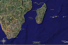
It is still not known where the Agulhas Current actually starts, but it is clear from satellite images that the Current is very much present between Maputo and Durban. Until fairly recently it was thought that the Agulhas Current flowed through the Mozambique Channel as a continuous current, and one finds this still being taught in schools today. Although an annual average may give that impression, flow through the channel is actually in the form of a series of eddies (the major cause and frequency of which is still under investigation).
The Current is fed from various sources - the largest contributor amongst these is water that is re-circulated in the South-West Indian Ocean. Other sources are the water coming through the Mozambique Channel in a series of eddies, and water flowing down the east coast of Madagascar. It has been shown that the Mozambique Channel eddies have a large impact on the biology within the Channel itself, and a large international study is currently focused on this area.
What occurs with respect to the waters flowing into the Agulhas Current south of Madagascar remains unclear to this day. Three hypotheses are put forward to explain this. Firstly, and apparently least likely, is that the East Madagascan Current continues to flow towards the east coast of Africa, feeding into the Agulhas. The second scenario is that the current breaks down into a train of eddies which then travel westwards towards the African continent. The final scenario is that the current retroflects, and eddies are shed and drift westward (in a similar fashion to the Agulhas retroflection).
There are numerous international and regional projects working towards answering some of the questions surrounding the Agulhas Current. These include the Agulhas Somali Current Large Marine Ecosystem, of which SAEON is an active participant. Ocean modelling also provides a useful tool in improving our understanding of oceanographic features such as the Agulhas Current.
An example of ocean model output can be seen in an animation from the NEMO model supplied by Dr Arne Biastoch of the Leibniz-Institut fϋr Meereswissenschaften (IFM-GEOMAR) in Germany http://www.ifm-geomar.de/~abiastoch. The animation shows the surface current speeds and highlights the extreme mesoscale2 variability in the Agulhas region.
1 Bathymetry is the study of underwater depth of the third dimension of lake or ocean floors.
2 Mesoscale — Pertaining to atmospheric phenomena having horizontal scales ranging from a few to several hundred kilometers, including thunderstorms, squall lines, fronts, precipitation bands in tropical and extratropical cyclones, and topographically generated weather systems such as mountain waves and sea and land breezes.


