
Rivers high, rivers dry, elephants nigh: Can Mapungubwe’s Greefswald Forest persist?
- Prof Tim O’Connor, SAEON Observation Science Specialist
The Mapungubwe area in South Africa’s Limpopo Province is renowned for its golden rhino artefact that has become the icon of a society which settled close to the Limpopo River for some 400 years between about 900 and 1300 AD.
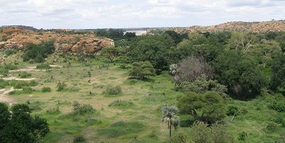
The river was not only the lifeblood of this society, which depended on flooding for irrigation of soils to be cropped, but it also offered a multitude of other resources. Riverine forest provided some of these. Stretches of forest along both the Limpopo and Shashe Rivers support monarchs of sycamore figs, anabooms, rain trees, nyala berries, fever trees, maroelas, boerbeans, and a smattering of other species.
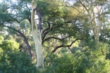 |
Stretches of forest along both the Limpopo and Shashe Rivers support monarchs of sycamore figs, anabooms, rain trees, nyala berries, fever trees, marula trees, boerbeans, and a smattering of other species (Picture: Mitzi du Plessis)
|
These verdant pockets of forest are in stark contrast with the surrounding landscape of semi-arid savanna dominated by the ubiquitous mopane tree. Most of our savanna rivers in the lowveld support open riverine woodland, but in their classification of the vegetation of South Africa, Mucina and Rutherford recognised the Limpopo riverine forests of this region as a distinct forest type.
Time brings change
Toward the end of the 13th century, owing to a rapid change in climate as the effects of the ‘Little Ice Age’ began to manifest, the Mapungubwe society moved on to other pastures. A sequence of three mega-floods over a period of a century or so occurred during the middle of the Little Ice Age, with unknown impacts on these forests, but their presence today indicates that they recovered.
 |
 |
|
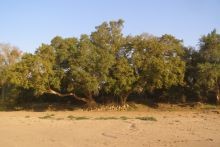
Intact river bank lined with fig trees (Picture: Tim O'Connor) |
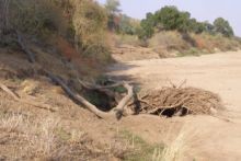
Eroded bank where many figs were lost (Picture: Tim O'Connor) |
Once most humans had departed, elephants once again became lords of the forest. White agricultural settlement started occurring toward the end of the 1800s. Hunting intensified, and by the 1900s elephants had been displaced further north. By the 1950s almost all land along the Limpopo River had been committed to agriculture.
Although an attempt to create the Dongola National Park failed, a handful of properties including the farm Greefswald were maintained as state properties. A substantial portion of riverine forest downstream of Greefswald was lost to the erection of a double electric security fence along the border, thereby increasing the conservation significance of the remaining forest upstream.
The bucolic serenity of the mopaniveld north of the Soutpansberg was set to change even further in the 1980s. A diamond pipe was discovered on the farm Venetia, destined to become the largest diamond mine in South Africa. The decision to develop the mine required water. Where else to look in this arid landscape than toward the Limpopo River some 40 km north?
Geography and access dictated that the Greefswald Forest was the most obvious point of supply. As the water was to be pumped from within the forest interior, a comprehensive assessment of potential impacts of water abstraction on vegetation was required. Contrary to popular belief, a diamond mine does not use as much water as some other land uses. The amount is equivalent to two centre-pivot irrigation schemes (duly purchased and discontinued by the mining company).
 |
|
The inner edge of the Greefswald forest with the Shashe River in the background (Picture: Tim O'Connor) |
Baseline survey
An approach for direct monitoring of the effect of water abstraction on the forest was devised and implemented by the relevant conservation agency. As a prelude to these efforts, baseline information of the composition and structure of the forest was provided in a scoping report, which forms the basis of the subsequent account.
Composition and structure of riverine forest or woodland is influenced primarily by access of plants to the water table, which in turn is a function of distance from and elevation above the river. Accordingly, for the baseline survey undertaken in 1990, the 60 hectares of forest were divided into different physiographic units reflecting these variables and each was sampled for shrubs, sub-canopy and canopy trees. Forest both upstream and downstream of the area of abstraction was sampled in order that comparisons could later be made if so desired.
At the time I thought it might be interesting if changes in the forest could be followed up at some later time, and so mapped the location of, and tagged, 428 canopy trees that were each measured for their size, degree of creeper infestation, and canopy volume lost to drought-dieback or windshear.
The effect of drought, flooding and elephant
Fifteen years later I was in a position to follow up on what had happened to this forest. But what are the chances of three infrequent events occurring within such a short time interval – short measured by the presumed lifespan of centuries for these trees?
Water abstraction for the mine had commenced in 1991. Shortly thereafter the country experienced one of the worst droughts on record – the 1991/2 season being the most affected – during which flow of the Limpopo River ceased completely during the summer. This had never been recorded before.
Second, the February 2000 flood was one of the largest on historical record. The Shashe River resembled the mighty Zambezi it used to be before river capture took place. Third, the creation of the Mapungubwe National Park signalled the return of elephants to the southern banks of the Limpopo.
It is obviously easier to establish what has caused the death or disappearance of a tree if a survey is conducted shortly following an event, but various lines of evidence can be used to ascribe mortality of an individual tree to an agent of mortality for long-lived trees even over such a long interval. This is only as good as the potential agents of mortality that are considered, and whether each would be distinct either in its spatial pattern or effect on the plant.
The set of mortality agents considered was drought, water abstraction, flood, wind-throw, salinisation, elephant use, lightning, creepers, and ring-barking by porcupine. In 2005, no trees had been killed through ringbarking by elephants, although about half the trees had been debarked to a degree.
The individual and cumulative impact of different agents on canopy trees was quite dramatic. Overall a quarter of the trees were lost, an effect which was greater than it may sound because many of these were the larger rather than the smaller canopy individuals. As a consequence, the forest was transformed to open woodland.
Drought accounted for 76 % of trees lost, and the 2000 flood for an additional 21 %. Creepers were implicated in the drought-related death of nearly half of the trees which succumbed to drought, but interestingly their effect was felt mostly by species with microphyllous (small) leaves, such as Acacia xanthophloea, rather than broad-leaved species.
It could not be determined directly whether a tree had succumbed to natural drought or deprivation of water supply by abstraction, but tree mortality within the area of abstraction was approximately one and a half times that of what it was without — a hard lesson learned, but pumping patterns now better accommodate drought.
Sycamore figs had lined the banks of much of the 4.4 km river front that was sampled, but a large proportion of these were lost downstream when the 2000 flood eroded up to 60 m of bank for a distance of at least 1.6 km. There was no evidence in support of mortality by ingress of saline water, porcupine, or windthrow, although the latter had reduced the size of a number of trees.
By 2007 the first deaths resulting from elephant ringbarking had started to occur, and more were likely to follow as the overall extent of debarking had increased. The species most targeted were maroelas, fever trees, and sycamore figs. Elephants, however, had also severed most of the creeper connections with the supporting tree, thereby reducing this stress on remaining canopy plants.
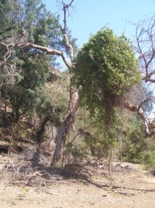 |
The first recorded elephant mortality — a ringbarked marula tree (Picture: Tim O'Connor) |
Each of the main canopy species experienced a different degree of impact from the different agents of mortality. Species such as rain trees, boerbeans, and nyala berries had been less affected by most agents, such that woodland composition was now becoming dominated by these seemingly more drought-tolerant species.
 |
 |
|
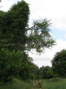
Fever tree smother by a climber — Combretum microphyllum (Picture: Tim O'Connor) |
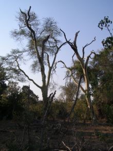
Drought dieback of fever tree (Picture: Tim O'Connor) |
Initial concern about the impact of water abstraction on riparian forest was ultimately dwarfed by the impacts of severe drought in combination with climber infestation, mega-flood, and elephants. The dominant species of this forest can live for centuries, such that a 17 year study is of short duration.
Useful pointers for SAEON
It may have been fortuitous to capture the effect of three major events that transformed the Greefswald Forest, but it may also presage future patterns of riparian forest change globally in response to increasing climatic variability and ever-increasing demands on water. At this time, a large water impoundment on the Shashe River is close to completion, and increasing amounts of water will be abstracted from the Limpopo catchment for power generation. SAEON has this data as one small means of assessing anticipated impacts of decreased flow on riparian habitats.
This account offers some useful pointers for SAEON in achieving its goals. First, it was born of an environmental impact assessment process. These are being undertaken all the time yet the data generated by this process is not easily accessed.
Second, it resulted from the interest of an individual rather than being the outcome of a formal procedure, yet most thinking is centred on organisational links. Third, even though it was not required, it was easy to set up sampling so that a follow-up could be conducted.
Perhaps other surveys could be influenced in a similar manner. Following the fate of individual trees rather than simply measurement of stands of vegetation improved considerably the quality of the study – all the more easily accomplished now in an era of GPS.
|
|
Buyelwa Sonjica, Minister of Water and Environment Affairs last month expressed concern about the proposed Vele coal mine at Mapungubwe. She said that the development has the potential to cause local as well as trans-boundary impacts including noise, air, water and visual pollution. "It was the expressed opinion of the department that the proposed open cast coal mine is an undesirable development for the area where it is proposed,” she said and added that ”the development could also hurt tourism at Mapungupwe, once the largest kingdom in the southern hemisphere and declared a world heritage site in 2003”. |