

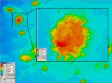
First deployment of the National Research Foundations’ Remotely Operated Vehicle (ROV)
|
The shelf areas of the world’s oceans constitute some of the most productive and ecologically important marine habitats. Yet more than 95 % of the seafloor is situated in waters deeper than 50 metres, which makes researching these areas unfeasible by means of SCUBA diving.
In 2008, the African Coelacanth Environmental Programme (ACEP) hosted by the South African Institute for Aquatic Biodiversity (SAIAB) through a grant from the Department of Science and Technology (DST), purchased a Remotely Operated Vehicle (ROV) to explore depth zones beyond SCUBA range.
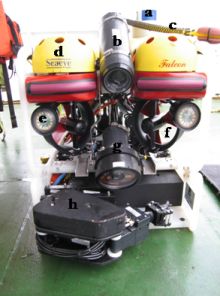
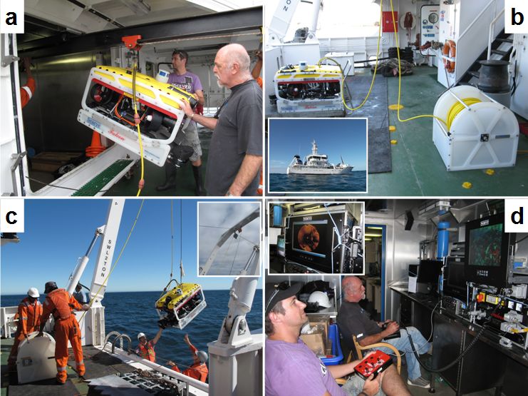
Depending on their purpose, ROVs come in all shapes and sizes (between 3 kg for limited inspections and 60 tons for subsea mining operations). ACEP’s “Falcon” is a relatively small (90 kg) ROV of the type ‘observation vehicle with limited intervention capabilities’. It carries a suite of cameras, lights and a manipulator arm (Figure 1).
Maiden voyage
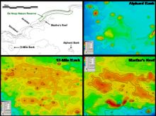
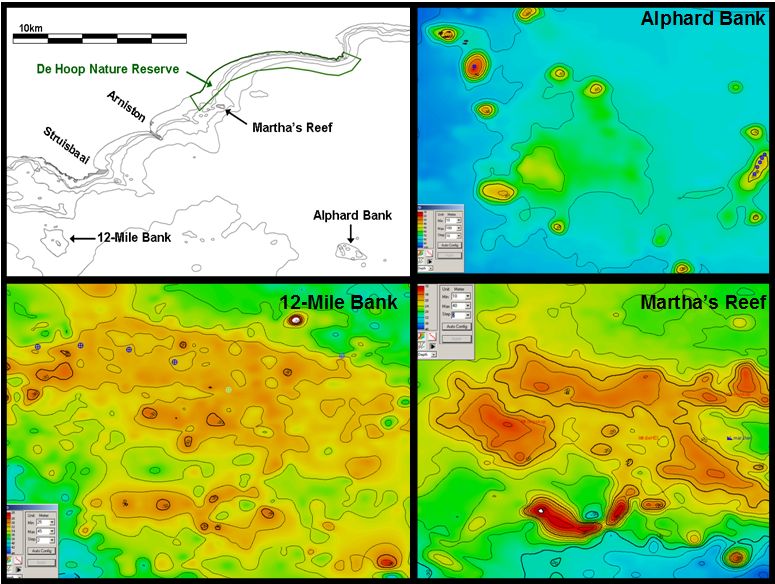
To get familiar with the new equipment, the ROV was deployed during a voyage of the research vessel Ellen Khuzwayo to the Agulhas Bank. This voyage formed part of an ongoing research project conducted by the Department of Agriculture, Forestry and Fisheries (DAFF) to assess linefish stocks and invertebrate communities associated with offshore reefs that cannot be sampled with trawl gear. These reefs consist of relatively shallow (20 - 70 metres) rocky banks and pinnacles between 20 and 150 km offshore (Figure 2).
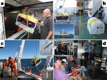
The Ellen Khuzwayo (Figure 3b insert), a purpose built 43-metre research ship which can work up to 200 nautical miles offshore, accommodates a crew of 21. She fulfilled all the requirements for initial trial deployments of the ROV at sea.
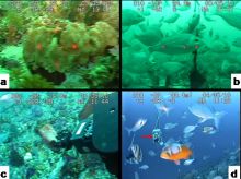
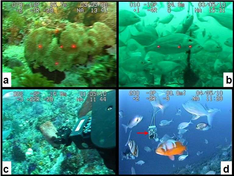
After the logistics of the deployment were dealt with (Figure 3), the first deployments were used to assess the ability of the ROV to conduct quantitative surveys over the relatively shallow Martha’s Reef and 12-Mile Bank. Here, we established methods to measure invertebrates (Figure 4a) and fish (Figure 4b) with the laser-scaling camera, sample invertebrates with the manipulator arm (Figure 4c) and count fish along a transect line or around a bait-container (Figure 4d).
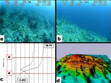
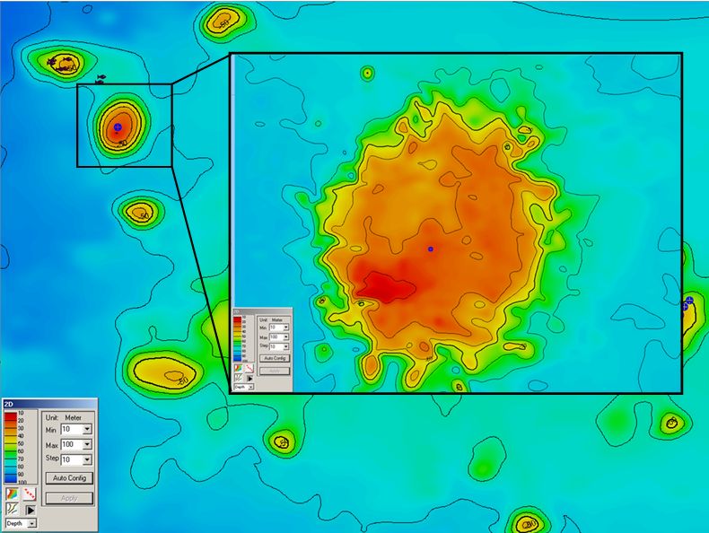
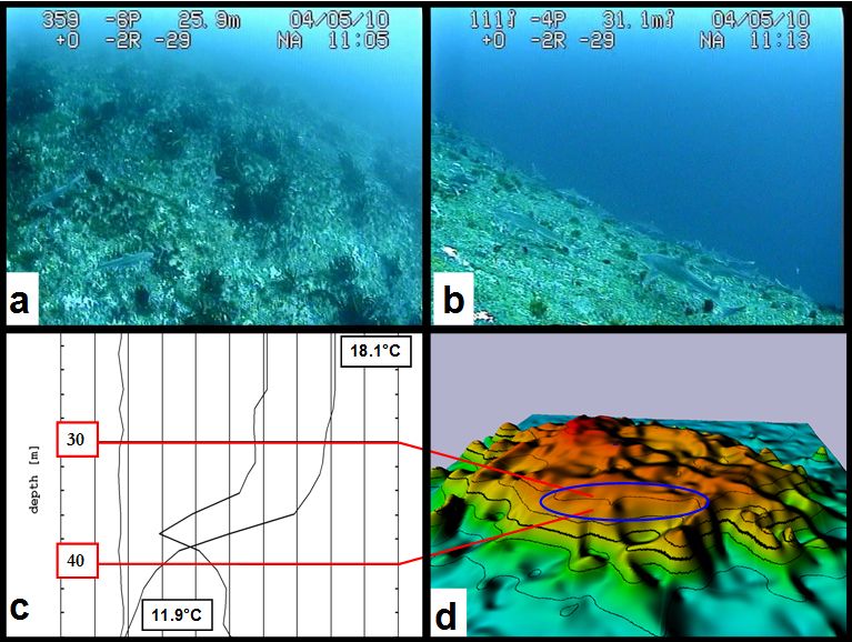
After these ‘practice trials’, our first exploratory dives took us to the Alphard Banks which are a cluster of slender pinnacles of volcanic origin. Much like on a mountain, the steep sloping seabed exhibits a rapid depth-related habitat succession (Figure 5).
The dome-shaped smooth pinnacle appeared at about 20 metres below the ocean, harbouring loose stands of spined kelp (Figure 6a) with patches of hydrozoans and encrusting sponges. At about 30 metres the kelp started to disappear and the encrusting invertebrates were replaced by a more diverse upright growing benthic4 community. This habitat change coincided with a sharp drop in temperature at about 35 metres (Figure 6c-d). Smooth-hound sharks were most abundant around the thermocline5 (Figure 6b).
Monitoring “patrolling” sharks
It seemed as if these sharks were ‘patrolling’ along an invisible line of rapid temperature change. This interesting phenomenon might be related to ‘dial vertical movements’ observed in other benthic, predatory fish such as dogfish sharks, where it also occurred in habitats with steep seabed topography and strong thermal stratification. In such environments, metabolic energy savings can be made by exploiting prey and thermal gradients.
As our cut-off depth for this first ROV trip was 40 metres (within SCUBA recovery range), we couldn’t explore the deeper slopes of the pinnacle. A follow-up trip to the Alphard Banks, this time without depth limit, is planned during the next linefish directed cruise of the Ellen Khuzwayo scheduled for November 2010.
1 Leader of SAEON’s Marine Protected Areas programme
2 Scientist, Department of Agriculture, Forestry and Fisheries (DAFF)
3 Scientist, Department of Environmental Affairs (DEA)
4 The benthic zone is the ecological region at the lowest level of a body of water such as an ocean or a lake, including the sediment surface and some sub-surface layers. (Wikipedia)
5 A thermocline is a thin but distinct layer in a large body of fluid (e.g. water, such as an ocean or lake, or air, such as an atmosphere), in which temperature changes more rapidly with depth than it does in the layers above or below. In the ocean, the thermocline may be thought of as an invisible blanket which separates the upper mixed layer from the calm deep water below. (Wikipedia)


