

SAEON’s Ndlovu Node monitors the polluting - and cleansing - of the Olifants River
|

Dr Tony Swemmer and Thabo Mohlala, SAEON Ndlovu Node
The increasing degradation of rivers in South Africa has been widely publicised, with reports of sewerage overflows, expanding mining operations and abstraction of river water becoming more and more common.
Will this lead to a massive loss of aquatic biodiversity in our major rivers, as it has done in most developed countries? And what are the consequences of such reductions in biodiversity for rural communities and farmers, who rely on water taken directly out of rivers?
While dysfunctional sewerage works and mine pollution are relatively new problems, rivers have been dealing with a certain degree of “pollution” for millennia. Faeces deposited in a river by a hippo or crocodile are essentially the same form of organic input as that coming out of dysfunctional sewerage works, while the salts and heavy metals that many mining operations cause to leach into rivers are not much different from those that would naturally leach into a river as it flows over certain rock types.
Rivers are living systems, and foreign inputs are soon broken down and transformed by a multitude of chemical and biological processes. As a result, substances entering a river are soon bound up in an aquatic ecosystem, or deposited in sediments on its base, and so the water in a natural river is always kept clean … quite different to what happens in a concrete canal in a city, where the pollution that enters at one point is still mostly all there at another point downstream.
With modern industrial and agricultural development, the amount and timing of inputs of pollutants into rivers has obviously changed drastically. It seems that rivers have the potential to process a fair amount of these increased inputs. For example, the water in many rivers in Limpopo, Mpumalanga and Gauteng is clean enough to be used by rural communities and farms, despite all the filth and pollution that enters these rivers as they flow through Pretoria and Johannesburg.
How much pollution can our rivers deal with?
However, there is a limit to how much a river can deal with. Considering that pollution inputs into South African rivers are unlikely to decline in the near future, the question of how much pollution a river can process, or ameliorate, is an important one. Equally important is to establish what environmental factors affect the ability of a river to deal with pollution.
Long-term research project
To investigate these questions, the SAEON Ndlovu Node initiated a long-term research project in the lower catchment of the Olifants River in the Lowveld of Limpopo and Mpumalanga. The Olifants River is regarded as one of the most degraded in the country, and suffers from an abundance of pollution in its upper catchment, mainly from coal mining on the eastern Highveld.
Further north, it flows through a major agricultural area, picking up eroded topsoil, unnaturally high inputs of nutrients from fertilisers, and various pesticides and other organic pollutants. After crossing the escarpment, the river gets some reprieve, as it flows through a region mainly used for nature conservation. The town and mines of Phalaborwa offer a final contribution of sewerage and mining pollutants before the river finally flows into the Kruger National Park and then on to Mozambique.
Despite all the upstream pollution, by the time the Olifants reaches Mozambique, its water is clean and safe to drink. It seems that the swathe of unused land, private game reserves and the Kruger National Park in the Lowveld play an important role in processing the substances that have entered its rivers upstream – vital for an ecosystem service of great importance to thousands of Mozambicans whose livelihoods depend on the quality, and quantity of water flowing out of South Africa.
The SAEON project, established in 2009, consists of ten sites – four on the Olifants itself, and six on major tributaries (Figure 1). Two of these tributaries (the Selati and Steelport Rivers) are sources of pollution, while two (the Klaserie and Blyde Rivers) are relatively pristine and provide a benchmark of good water quality.
Using the composition of insect and fish communities as indicators
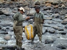
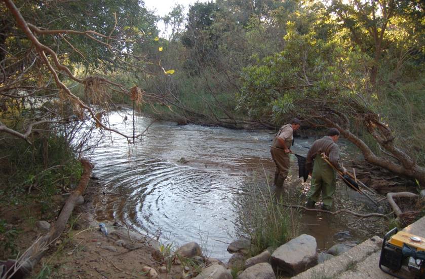
At each site, water quality is measured monthly using a selection of physical and chemical samples, and the well-established SASS (South African Scoring System) method which uses the composition of insects living in the river water as an index of pollution. Fish communities are also sampled, although less frequently.
This amounts to a sampling regime which is more intensive, in both space and time, than the water quality monitoring undertaken by the Department of Water Affairs. This was considered necessary to detect major pollution events, and to track improvements in water quality as pollutants are processed along the length of the river.
Results to date have revealed that common measures of water quality fluctuate greatly from month to month, even in relatively unpolluted rivers (Figure 2). This indicates that regular sampling is required to detect pollution events, and to establish a trend of declining water quality with any confidence.
The data also show that water quality is consistently higher at sites within conservation areas (Figure 3), illustrating the value of these areas for cleaning up polluted rivers.
Professor Paul Fouche (University of Venda) and Dr Wynand Vlok (previously with the University of Limpopo) were instrumental in establishing this research, assisting Dr Tony Swemmer, manager of the SAEON Ndlovu Node with the design and providing training for MSc student Thabo Mohlala, the SAEON technician responsible for the sampling.
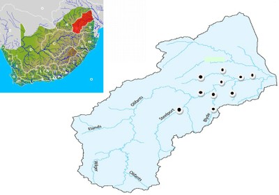
Figure 1. Map of the Olifants River catchment, showing the 10 sites monitored by SAEON’s Ndlovu Node.
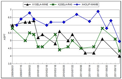
Figure 2. A time series showing two and a half years of SASS data sampled at monthly intervals in the Selati River (black and green lines) and the Olifants River (blue) downstream of where it is joined by the Selati. ASPT = “average score per taxon” – higher values indicate the presence of aquatic insects that are sensitive to pollution. Higher values therefore indicate cleaner water. The declining values for the Selati River are evident both upstream (green line) and downstream (black line) of the Phalaborwa mines, and are probably the result of sewerage inputs from the town of Phalaborwa, rather than from mining pollution.
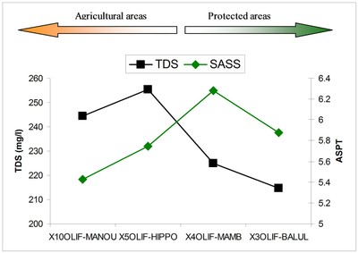
Figure 3. Average values for SASS and TDS (total dissolved solids) for the four sites located on the lower Olifants River. Both indexes of water quality show a trend of improved quality as the river flows from rural, agricultural areas around the escarpment into the conservation areas of the Lowveld. This is likely to be a result of the input of clean water from a major tributary in good condition (the Blyde River), reduced abstraction, and the good condition of the riparian vegetation in the conservation areas.


