
SAEON monitors impact of climate change on salt marsh biodiversity
|
SAEON is the principal investigator in a study to investigate the influence of predicted climate change and sea-level rise on the diversity, distribution, abundance and community composition of salt marsh in the Swartkops, Kromme and Knysna estuaries. The study was originally funded by the Marine Living Resources Fund1.
South Africa is likely to experience substantial climate change in the next decades, leading to a dramatic decline in biodiversity (Van Jaarsveld & Chown 2001). The predicted changes in the rate of sea-level rise, as a result of global warming, will have important impacts on the coastal zone, displacing ecosystems, altering geomorphological configurations and their associated sediment dynamics, and increasing the vulnerability of social infrastructure.
Sea-level rise
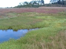
Coastal wetlands (collectively comprising salt marshes, mangroves, intertidal and supratidal areas) could experience substantial losses as a result of sea-level rise. These economically valuable ecosystems are highly productive and provide a number of important functions such as flood and storm protection, waste assimilation, nursery areas for fisheries, supply of organic matter to estuarine and marine environments and nature conservation (Nicholls et al. 1999; Lutjeharms et al. 2001).
Tide gauge measurements from South Africa indicate that sea levels have risen by approximately 1.2 mm/year over the last three decades, similar to international estimates (Brundrit 1995), although recent observations from satellites indicate that the global sea levels have been rising by 3.3 + 0.4 mm/year from 1993-2006 (Rahmstorf et al. 2007). The current trend of rising sea level is expected to accelerate in the future, with recent estimates indicating a 12.3 cm rise by 2020, 24.5 cm rise by 2050 and 40.7 cm rise by 2080 (Nicholls et al. 1999; Kirwan & Murray 2008).
Decline in river runoff
In addition to sea-level rise, Clarke et al. (2000) estimated that runoff from rivers on the west and south coasts would decline by 11– 84%, while those on the east coast would change by anything from -21% to +10%, making the percentage runoff change in southern Africa amongst the highest in the world (Arnell 1999).
The reduction in freshwater reaching the estuary will have a direct impact on the ecological functioning of the salt marsh because each species has a specific freshwater requirement. A further impact will be the reduction in sediment input from the catchment, reducing the ability of the salt marsh to accrete at the same rate as eustatic sea level rise.
If salt marshes are to survive rising water levels, they must be able to accrete at a rate such that surface elevation gain is sufficient to offset the rate of water level rise (Cahoon et al. 1995). A number of studies have shown that coastal marshes are able to accrete at a rate equal to the historical rate of eustatic sea-level rise (1–2 mm/year) (Plater & Kirby 2006; Goodman et al. 2007).
Understanding shoreline response is critical
Marginal and emergent vegetation such as salt marshes and mangroves contribute significantly to estuarine productivity and any negative effects on these communities could thus feed through to estuarine associated fish and fisheries. In the face of a global rise in sea level, understanding the response of the shoreline, the change in productivity of coastal wetlands and its impacts on faunal populations and other coastal ecosystems, to changes in sea level is a critical scientific goal to inform policy makers and managers.
RSET monitoring
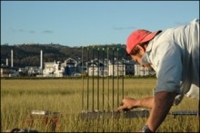
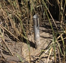
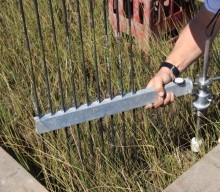
SAEON is attempting to understand the response of the salt marsh by measuring vegetation cover, soil characteristics, vertical accretion, short-term sedimentation, soil vertical elevation change, shallow subsidence and horizontal shoreline change at nine sites with varying sediment availability and wave energy in the Swartkops, Kromme and Knysna estuaries. Precise measurements (within 1 mm) of sediment elevation in the intertidal salt marsh have been made over a period of three years relative to a fixed subsurface datum using a Rod Sediment Elevation Table (RSET). A RSET was constructed according to the specifications published by Cahoon et al. (2002).
SET monitoring provides a time series of the integrated effect of surface and below ground processes on sediment elevation. Measuring sediment elevation with a SET involved the installation of a permanent receiver in a concrete casing in the Spartina maritima zone.
The SET provides a non-destructive method for making highly accurate and precise measurements of sediment elevation of intertidal and subtidal wetlands over long periods of time relative to a fixed subsurface datum. This technique overcomes many of the limitations of methods currently used to estimate elevation such as sedimentation pins, and precision surveying.
Repeated measurements (three sets) of elevation were taken at nine points on eight fixed different orientations at each station, i.e. 5832 measurements in total every six months. Preliminary results (before determination of the subsurface datum) for the Knysna Estuary are shown in Figure 1 below.
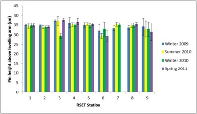
Figure 1. RSET pin heights for the Knysna Estuary over four sampling periods.
The only significant change in sediment elevation at the 27 stations in the three estuaries was recorded at Station 3 in the Knysna Estuary (Figure 1), located in the Ashmead Channel. This seasonal variance could be related to sediment input and scouring from the Bagai tributary.
Baseline for measuring change
SAEON will continue to monitor the sediment elevations at the 27 stations in the three estuaries on an annual basis. It is expected that a few more years of data collection will be necessary to set a baseline against which change could be measured. Vegetation (n > 20000) and sediment data (n = 1212) are being analysed at present.
Based on the preliminary data it is hypothesised that the strongest physical variables that determine vegetation composition and distribution are sediment salinity and elevation. Both variables will be influenced by direct and indirect effects of climate change and sea level rise and it is further hypothesised that salt marsh community and species distributions and cover abundance will be significantly altered within the next ten years.
Long-term monitoring of the salt marsh sediments in these three estuaries will continue indefinitely to test the following main hypotheses:
- The Kromme Estuary is starved of fine sediment and a significant portion of the salt marsh will drown with increasing sea levels.
- The Swartkops Estuary has the largest diversity and area cover of salt marsh habitat that, together with the ample supply of fine and course sediment, will ensure the survival of the marsh with rising sea levels.
- The Knysna Estuary receives sufficient sediment from the catchment, but coastal squeeze will restrict the landward transgression of salt marsh, resulting in a significant loss of salt marsh habitat and area with increasing sea levels.
1Now provincial research projects funded by the Department of Agriculture, Forestry and Fisheries and Oceans and Coasts, Department of Environmental Affairs
References
Arnell, N.W. 1999. Climate change and global water resources. Global Environmental Change 9:31–49.
Brundrit, G.B.. 1995. Trends in southern Africa sea level: statistical analysis and interpretation. South African Journal of Marine Science:16: 9–17.
Cahoon, D., Reed, D. & Day, J. 1995 Estimating shallow subsidence in microtidal salt marshes of the southeastern United States: Kaye and Barghoorn revisited. Marine Geology 128, 1–9.
Cahoon, D.R., Lynch, J.C., Hensel, P., Boumans, R., Perez, B.C., Segura, B. & Day, J.W. 2002. A device for high precision measurement of wetland sediment elevation: I. Recent improvements to the sedimentation-erosion table. Journal of Sedimentary Research. 72 (5): 730-733.
Clarke, B.M., Steffani, N.C., Young, S., Richardson, A.J. & Lombard, A.T. 2000. The effects of climate change on marine biodiversity in South Africa. Report prepared for the Foundation for Research Development, South African Country Study on Climate Change, Vulnerability and Adaptation Assessment, Marine Biodiversity Section, Pretoria.
Goodman, J.E., Wood, M.E. & Gehrels, W.R. 2007. A 17-yr record of sediment accretion in the salt marshes of Maine (USA). Marine Geology 242: 109–121.
Kirwan, M.L. & Murray, A.B. 2008. Ecological and morphological response of brackish tidal marshland to the next century of sea level rise: Westham Island, British Columbia.Global and Planetary Change 60: 471–486.
Lutjeharms J.R.E., Monteiro, P.M.S., Tyson, P.D., Obura, D. 2001. The oceans around southern Africa and regional effects of climate change. South African Journal of Science 97:119–30.
Nicholls, R.J., Hoozemans, F.M.J. & Marchand, M. 1999. Increasing flood risk and wetland losses due to global sea-level rise: regional and global analyses. Global Environmental Change 9: S69 - S87.
Plater, A. & Kirby, J. 2006. The potential for perimarine wetlands as an ecohydrological and phytotechnological management tool in the Guadiana estuary, Portugal. Estuarine, Coastal and Shelf Science 70: 98-108.
Rahmstorf, S., Cazenave, A., Church, J.A., Hansen, J.E., Keeling, R.F., Parker, D.E.& Somerville, R.C.J. 2007. Recent Climate Observations Compared to Projections. Science 316 (5825): 709.
Simas, T., Nunes, J.P., Ferreira, J.G. 2001. Effects of global climate change on coastal salt marshes. Ecological Modelling 139: 1–15.
Van Jaarsveld, A.S. & Chown, S.L. 2001. Climate change and its impacts in South Africa. TRENDS in Ecology & Evolution 16 (1): 13 – 14.