Coastal radar network set to boost SA marine research
|
By Dr Wayne Goschen, Egagasini Marine Offshore Node and Dr Tommy Bornman, Elwandle Marine Coastal Node
SAEON marine scientists are collaborating with colleagues from a range of local and international institutes on a project to install a high-frequency (HF) radar network around the coast of South Africa.
Collaborating institutes are the Nelson Mandela Metropolitan University (NMMU), South African Weather Service, University of Cape Town's Marine Research Institute (Ma-Re), Rutgers University and Nansen Environmental and Remote Sensing Center (NERSC-Norway), as well as CODAR Europe.
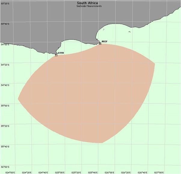
HF radar measures surface currents and waves up to 180 km offshore (beyond the Agulhas Current), but can also be configured for smaller areas such as harbours and bays. The measurements are in real time, with a resolution of a few kilometres. Nelson Mandela Bay Metropolitan Disaster Management has also recognised the value of the radar network and participated in the discussions.
Visual products to interpret sea surface movement
Excellent visual products are available from the data to interpret sea surface movement. Their uses include search and rescue, oil spills, ships entering/leaving harbours, offshore ship tracking, ocean surface currents, waves, tsunamis and storm surges, operational oceanography, remote sensing data validation, ocean modelling and physical oceanographic research.
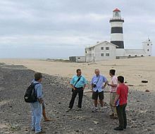
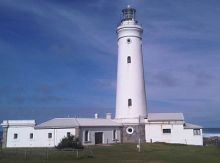
SAEON marine scientists Dr Wayne Goschen and Dr Tommy Bornman, who are also research associates at the NMMU Coastal and Marine Research Unit, are contributing to the planning and implementation of the project. During the first phase of the project, the team visited the lighthouses at Cape Recife and Cape St Francis.
Lighthouses provide excellent locations for the installation of Coastal HF Radar sites because of their unobstructed view of the sea, their secure buildings and as a source of electricity. These two sites will be the first ones operational in the national network and will also be the first coastal HF radar to be deployed in Africa with research capabilities.
Capacity building and training
The project will facilitate the teaching of oceanographers in the use of HF radar products for research purposes that will ultimately protect property and life along the SA coastline. Technicians, engineers and maritime safety personnel will also be trained in the maintenance, design and use of HF radar.
CODAR and its South African partners will discuss capacity building and training requirements in the near future.
|