
Conquering Compassberg
The iconic mountain
Compassberg, the highest peak in the Sneeuberg range, resembles a compass needle towering 2 502 metres high. From its summit one gets a spectacular view all around the compass, and on a clear day one can easily locate the small town of Nieu-Bethesda to the south.
|
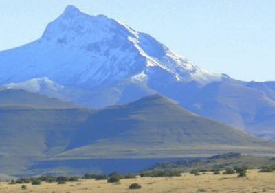
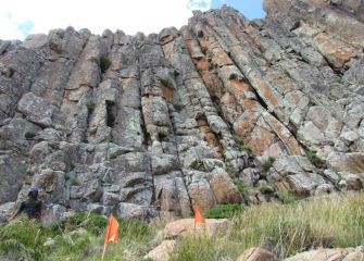
The gigantic grey walls of dolerite flows sediments offer a breath-taking view of the mountain itself. The mountain harbours a diversity of species, including endemics. High on the list of important species flutters a butterfly, the Compassberg skolly (Thestor compassbergae), found only the slopes of this one mountain, and nowhere else.
Compassberg, together with its neighbouring mountains, provides a critical water catchment area covering over 40 000 hectares of livestock and game farms. In fact, it was recognition of this precious water catchment function that led to the proclamation of the first protected environment in the Karoo - the Compassberg Protected Environment (CPE).
The CPE also benefited two shrubs, Euryops petraeus and Selago retropillosa, habitat specialists listed as rare on the Red List of South African Plants. In recent years, the Compassberg hiking trail gained popularity and is one of the main outdoor adventures in the area.
Field work experience
In December 2013 the Arid Lands Node team, together with SAEON's Observation Science Specialist, Prof. Tim O'Connor, conducted a reconnaissance survey of the Compassberg. We found that besides differences in altitude, there were also marked differences in grazing pressure, particularly by large numbers of feral horses.
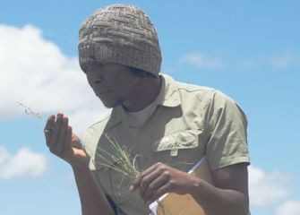
Three months later, I was back on Compassberg to initiate the data collection with fellow Arid Lands Field Technician Marco Pauw. By merely looking at the mountain, it was clear field work was going to be tough ... and it was, especially the first few days. The treacherous mountain terrain was difficult to negotiate, but within three days of intense work, our fitness levels rose and we became as agile as klipspringers, hiking at least 4.5 km daily to the foot of the mountain, then scrambling up the mountain, and all again later in reverse.
One afternoon we noticed storm clouds gathering above us, but we decided to stay and finish the plot. That was a mistake. Within a few minutes the clouds got denser and suddenly we were caught in a hail storm, coupled with intense thunder and lightning. With the realisation that the vehicle was parked over 4 km away across mountainous terrain, we had no choice but to weather out the storm, which lasted an arduously long half an hour. Now we can be sure: an Arid Lands Node Technician can tackle any terrain in any weather.
|
Vegetation sampling
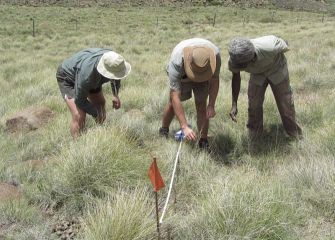
Despite being the highest peak in the Sneeuberg range and having endemic species, to date no botanical studies have made any attempt to investigate the vascular flora of Compassberg, and a description of vegetation on this mountain is non-existent. Owing to its height and herbaceous cover over the altitudinal range, the mountain provides an ideal opportunity to investigate the altitudinal shift in climate and vegetation, particularly C3 and C4 grass species.
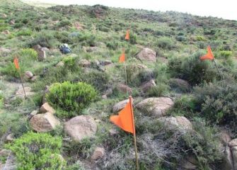
As a spatially comprehensive and explicit survey of the floristic composition would help SAEON develop indicators of environmental change, we set up four transects on the north-eastern slope. In order to ensure comprehensive coverage, circular quadrats (1.8 m radius) were placed at every 50 m increase in altitude, or 100 m ground distance up the slope. The formidable cliffs on the west-facing slope have defeated our plans to set up transects there to reach the upper slopes, but we hope to get there soon. For the immediate future we are also planning to carry out spatially explicit surveys on various faunal components of biodiversity, such as insects, reptiles and small mammals.
The Arid Lands Node would like to thank Brenda James for providing us with accommodation and supplying us with fresh milk from the farm. We are also grateful to Peet van Heerden (Chair of the Farmers' Association), who gave us invaluable information about the mountain, and to Schalk Pienaar for granting us permission to access the western slope of Compassberg.
|