
Shedding light on Mapungubwe's disappearing riverine forest
|


|
Riparian vegetation, roughly described as the vegetation that hugs waterways such as rivers, is renowned for its scarcity.
Because rivers flow through a variety of landscapes, the vegetation itself varies greatly, but in general the different types are unified by the fact that they are in the way of water-thirsty developments such as agriculture, and suffer the consequences once water is abstracted upstream. Most of the Orange River's riparian vegetation, for example, has been classified as critically endangered because it has been lost due to irrigation farming against the river, dams that have been constructed in the river's upper reaches and the impact of alien plants and livestock.
This ‘green' part of the river ecosystem fulfils various essential functions. It helps to regulate the river flow by absorbing water into its root systems and physically blocking water to moderate the impact of flooding on the surrounding areas. It filters pollutants from the surrounding land and air to prevent these from entering the river. It is also an important habitat for many plants and animals.
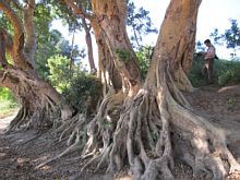
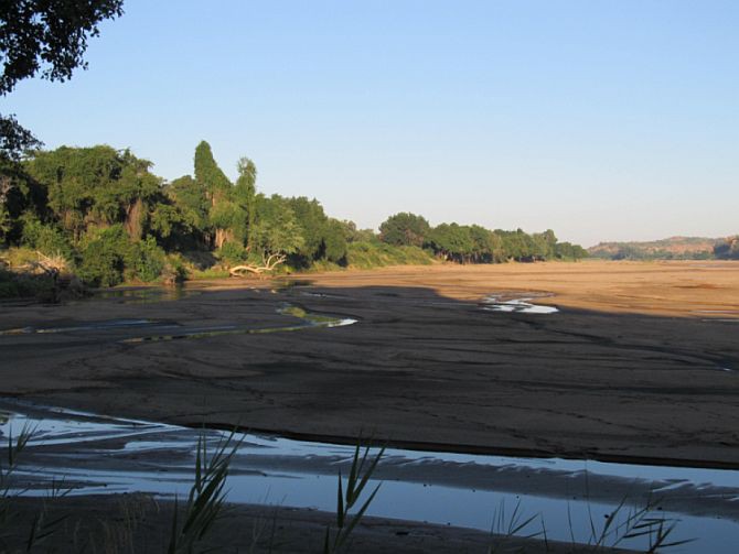
Greefswald riparian forest
The Limpopo is another river of which huge swaths of riparian vegetation have been lost. That which remains in the rich alluvial deposits along the river is of prime conservation importance. Of particular interest is a stretch of vegetation close to where the Limpopo meets the Shashe River and the point where South Africa, Botswana and Zimbabwe meet. Referred to as the Greefswald riparian forest, it is protected by the Mapungubwe National Park and World Heritage Site.
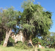
Greefswald was once a true, closed-canopy forest, dominated by giant Fever trees, Ana trees, Leadwoods, Sycamore Figs and Nyala trees. Despite ongoing mortality of these giants since the 1990s it is still considered to be Lowveld Riverine Forest and is one of the few remaining examples of this rare vegetation type to be found in South Africa. As a result, it was included on the National List of Threatened Ecosystems produced by the South African National Biodiversity Institute (SANBI) in 2011.
The past two decades or so have been a tumultuous time for this piece of forest. From 428 trees tagged for measurement in 1990 in a 40 ha area, a quarter were lost 15 years later. As a consequence, the forest has been transformed to open woodland, and the density of the remaining tall trees is still declining (see Figure 1 below).
|
Annual monitoring of the more than 300 remaining tall trees, from 2011 onwards, has revealed that the population of all the large forest species is still declining, and alarmingly fast for the two species that used to be the dominants of the Greefswald Forest.
What has happened to the forest?
Various factors are thought to be responsible for the decline of the forest, but the relative importance of each of these, in the past and currently, is not clear.
In 1990, 428 canopy trees in a 40 ha area of the Greefswald canopy forest were mapped and tagged, and measured for their size, degree of creeper infestation and canopy volume by Prof. Tim O'Connor (currently Observation Science Specialist for SAEON). That was done to monitor any impact of water abstraction for the Venetia mine, which commenced the following year.
The De Beers Venetia Mine is an opencast kimberlite operation located approximately 80 kilometres west of Musina and some 500 km north of Johannesburg. It is South Africa's largest producer of diamonds. The mine abstracts the majority of its water from a wellfield in highly porous alluvial deposit located on Greefswald (which was once a farm). Water is also abstracted from another alluvial aquifer downstream (the Schroda wellfield) when necessary.
During the 1991/2 season, the country experienced one of its worst droughts on record, during which flow of the Limpopo River ceased completely during the summer - something that had never been recorded before. After that came the February 2000 flood - one of the largest on historical record. Shortly thereafter, the Mapungubwe National Park was created, and elephants returned to the southern banks of the Limpopo. These three events had a massive impact on Greefswald.
|
When O'Connor returned 15 years later, he found that "the individual and cumulative impact of different agents on canopy trees was quite dramatic"- 25% of the trees tagged in 1990 had died. He used various lines of evidence to ascribe mortality to various agents: drought, water abstraction, flood, creepers and porcupine.
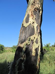
In 2005, no trees had been killed through ring-barking by elephants, although about half the trees had been debarked to a degree. Drought accounted for 76% of trees lost, and the 2000 flood for an additional 21%. Creepers were implicated in the drought-related death of nearly half of the trees which succumbed to drought.
It could not be determined directly whether a tree had succumbed to natural drought or deprivation of water supply by abstraction, but tree mortality within the area of abstraction was approximately one and a half times that of what it was without. Sycamore Figs had lined the banks of much of the 4.4 km river front that was sampled, but a large proportion of these were lost downstream when the 2000 flood eroded up to 60 m of bank for a distance of at least 1.6 km.
By 2007, the first deaths resulting from elephant ring-barking had started to occur, and more were likely to follow as the overall extent of debarking had increased. The species most targeted were Marulas, Fever trees and Sycamore Figs. By 2014, SAEON's Dr Tony Swemmer found that over 97% of all large trees in the forest had suffered some form of elephant damage. Elephants, however, had also severed many of the creeper connections with infested trees, thereby reducing this stress on remaining canopy plants.
Each of the main canopy species experienced a different degree of impact from the different agents of mortality. Species such as Apple-leaf, Weeping Boerbean, and Nyala trees had been less affected by most agents, such that woodland composition was now becoming dominated by these seemingly more drought-tolerant species.
O'Connor found that initial concern about the impact of water abstraction on riparian forest was ultimately dwarfed by the impacts of severe drought in combination with climber infestation, a mega-flood and elephants.
Yet, since that time, the trees' decline has continued, even though the dramatic flood and drought events were not repeated (the January 2013 flooding of the Limpopo River had little impact). "We have returned to monitor the status of the tall trees, and tree recruitment, every year for the last four years and found that the loss of tall trees is continuing," says Swemmer.
Investigating the problems from different angles
In addition to ongoing mortality of large, adult trees, there is little or no recruitment of juvenile trees of the forest species. To work out why, new research has been initiated by SAEON. This includes comparing mortality rates with other patches of forest where there is no water abstraction (in collaboration with SANParks), a stable isotope study to identify sources of water used by the forest trees (in collaboration with Kansas State University, USA) and the deployment of a state-of-the-art sensor to monitor soil water content.
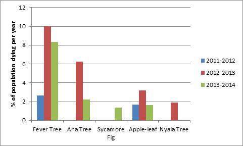
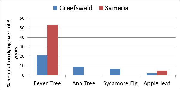
A similar number of forest trees were tagged in another part of Mapungubwe National Park by SANParks scientists, and together with SAEON these are now monitored annually in the same way the Greefswald trees are. These data reveal similarly high levels of mortality in recent years for one species, but not for others (see Figure 2 below). This reiterates the complexity of the situation, indicating different causes of mortality for different species. While elephant impacts are likely to be the cause of the very high rates of mortality of Fever Trees, it appears that other factors, such as water stress, are contributing to higher rates of mortality in Greefswald relative to areas upstream.
|
The impact of elephants has probably become unnaturally high in recent years. This can be attributed to the combination of the effects of numerous waterholes in game reserves in nearby Botswana, and a channelling effect of the extensive agriculture found either side of the park, which forces a large population to utilise a relatively narrow stretch of forest during the dry season.
In order to better understand the role of water stress in driving mortality, SAEON scientists collaborated with Dr Jesse Nippert from Kansas State University to identify exactly where the remaining forest trees are getting their water from. Nippert is a specialist in the use of stable isotopes to study plant water use. By analysing water in the stems of trees of each of the dominant species, Nippert was able to determine whether trees were primarily using water derived from the river (via the alluvial aquifer) or from rain (via shallow soil water).
Final results from this study are still pending, but preliminary indications are that the trees use a combination of sources, and that those currently showing the highest mortality (Fever trees and Ana trees) do make use of the alluvial aquifer during the dry season. Whether water abstraction by Venetia is causing a shortage of water for these trees cannot yet be confirmed.
Old questions, new technology
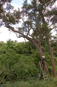
Launched in March this year under the auspices of SAEON's hydro-meteorologist, Prof. Colin Everson, a cosmic ray probe was installed to monitor the soil moisture and the amount of water inside the canopy of trees at Greefswald. In addition, "heat pulse velocity" probes inserted into the trunks of a few selected trees are being used to monitor the rate at which water moves up these trees, from the roots to the canopies. Reduced rates of flow indicate water stress, and together with the soil moisture data from the cosmic ray probe, these data will be used to design an early-warning system for detecting water stress in trees.
|
This is a collaborative effort supported by grants from USAID-National Science Foundation (PEER), and the South African National Research Foundation (NRF-RISP), while the physiological and ecological work is supported by De Beers, the World Wide Fund for Nature (WWF) and SANParks. Everson, together with Trenton Franz from the University of Nebraska-Lincoln, are now in the process of testing this technology, originally developed for agriculture.
The device sends data in real time to the Cosmic-ray Soil Moisture Observing System (COSMOS) server, which makes use of a novel, non-contact technique capable of measuring average soil water content over a footprint of 34 hectares (a circle with a radius of 330 m) and depths up to 50 cm. The aim of the project is to fill a serious handicap that currently exists in soil moisture measurements, namely the mismatch between limited point measurements using contact methods and remote sensing estimates over large areas (100 km² - 2500 km²) without thick vegetation cover.
The method involves measuring low-energy cosmic-ray neutrons above the ground, whose intensity is conversely correlated with soil water content and with water in any form above the ground level (the contributions of subsurface and surface waters are distinguishable). The data are freely available in near real-time over the Internet, and include neutron counts in two energy bands, soil water content, snow pack water equivalent (and possibly also vegetation water equivalent), temperature, pressure and relative humidity.
The team are combining this data with in-field monitoring of the vegetation to determine if, and when, the forest is being affected by water stress caused by groundwater pumping for the De Beers Venetia mine. This is particularly important as the mine will be applying for a new water licence to meet its increasing water needs.
The project is set to continue until November, so the researchers will only have a data set from one season. Still, if deemed successful, it might continue to run and be expanded to other areas in South Africa. While it is yet to be confirmed, riparian vegetation of the Orange River might be a suitable target.
The future of the forest
It is not sure exactly when, and how, the Greefswald forest formed. It could well have been a result of the rise of Mapungubwe civilization in the area between 1000 and 1300 AD. Perhaps soldiers and farmers kept elephants out of the riverine areas, and together with the higher rainfall of that time, this may have enabled the current trees to establish. As such, it is not clear what the natural ecological state of the area is.
While research findings will help to elucidate the ecological processes causing the recent decline of the forest, SANParks (the current custodians of the area) will have to decide whether to attempt to restore the forest, in order to preserve the significant biodiversity it contains, or allow contemporary ecological processes to operate freely, even if that means a complete absence of tall riparian trees.
|
Sources:
- http://cosmos.hwr.arizona.edu/
- The COsmic-ray Soil Moisture Observing System (COSMOS) by M. Zreda, J. Shuttleworth, X. Zeng and C. Zweck - University of Arizona
- From www.saeon.ac.za: Cosmic ray probe to aid Mapungubwe's threatened endemic forest
- From www.saeon.ac.za: Rivers high, rivers dry, elephants nigh: Can Mapungubwe's Greefswald Forest persist? By Prof Tim O'Connor, SAEON Observation Science Specialist
- SANParks Times, June 2013 edition: The fever berry's novel take-over strategy