
Surface and groundwater observations from different scales help to understand and model hydrologic processes in the Baviaanskloof catchment
|


The semi-arid, mountainous catchment areas in the Table Mountain Group geologic formation, which extends along South Africa’s southern cape from Cape Town to Port Elizabeth, are heavily relied upon for regional water supply.
The large, fractured rock mountains and coarse valley fills and floodplains that characterise these catchments often result in relatively complex surface-subsurface flow pathways for water reaching rivers and reservoirs.
|
Gaining a better understanding of the hydrologic processes in these catchments can help assess how streamflow and groundwater are likely to respond to changes in land use and climate. The catchment area of the Baviaanskloof River in the Eastern Cape provides an example of this and ongoing monitoring of rainfall, temperature, surface, and groundwater supported by SAEON is providing useful insights on its hydrology.
Key source of water supply
The Baviaanskloof catchment is bounded by the Baviaanskloof and Kouga Mountains located at the western border of the Eastern Cape Province. The Baviaanskloof River and Kouga River to the south feed into the Kouga Reservoir, the single largest water supply source in the Algoa region, which includes Nelson Mandela Bay Municipality, the Gamtoos agricultural area, and several surrounding towns.
|
Despite only receiving about 300 mm mean annual rainfall, infiltration and groundwater recharge during periodic wet spells and the large size of the catchment (1,234 km2) means there is perennial outflow. Large-scale losses of vegetation cover on the hillslopes due to high intensity livestock grazing in sensitive subtropical thicket vegetation of the Baviaanskloof has increased surface runoff and erosion during intense storm events (van Luijk et al., 2013). This may have also influenced the catchment’s hydrology by increasing flood intensities and decreasing recharge and base-flow in dry periods (Glenday, 2015).
|
Through research facilitation by the nonprofit organisation Living Lands, and with the support of SAEON and DEA-NRM (Department of Environmental Affairs – Natural Resources Management), a network of monitoring sites covering various hydrometric variables has been established in the catchment.
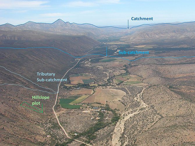
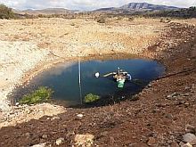
Surface and groundwater flows have been monitored at different scales, from surface runoff and soil moisture measured across a two-hectare hillslope plot, to streamflow from a 9 km2 tributary sub-catchment, to streamflow from the entire 1 234 km2 catchment area. Groundwater levels in the central floodplain have been monitored at seven sites along the length of the valley.
|
Hydrologic models
Catchment-scale hydrologic models allow us to apply our understanding of water flows to look at future climate and land cover scenarios and their likely implications for ecosystems, water resource management, and flood management. However, large arid and semi-arid catchments like the Baviaanskloof, are notoriously difficult to model because significant proportions of their total outflows flow underground, requiring more complex calculation (Clark et al., 2008).
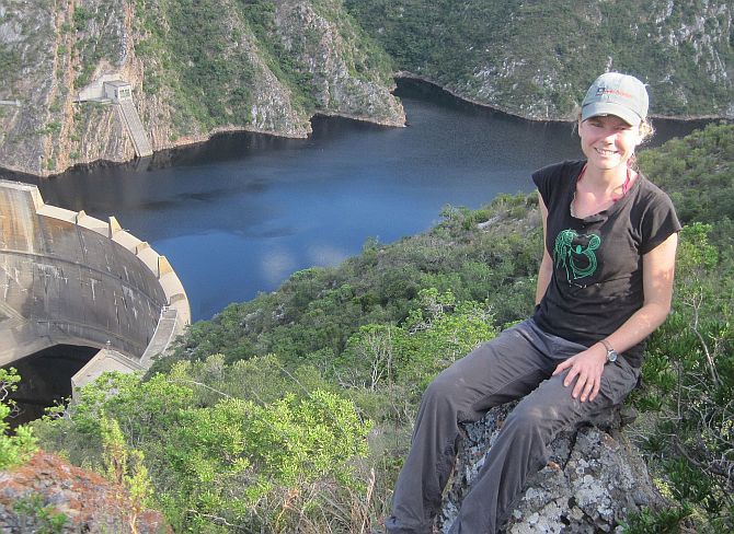
Julia Glenday, currently a PDP* postdoc with SAEON’s Fynbos Node, has been working on data collection and analysis in the Baviaanskloof for her PhD research with the University of California, Santa Barbara. She is continuing her postdoctoral work using this information to build and test numerical models of the catchment’s hydrology.
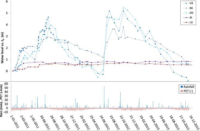
Having information from different scales and having concurrent surface and groundwater measurements in the Baviaanskloof has been extremely helpful in improving understanding of flows of water from the mountains and hillslopes, through the floodplain, into the river channels and to the Kouga Dam. For example, it was observed that after large winter storms, the groundwater levels in the floodplain could rise several metres and peak weeks following an event, while mountain tributary streams, which provide surface water to the floodplain, only flowed for a few days immediately after the storm.
|
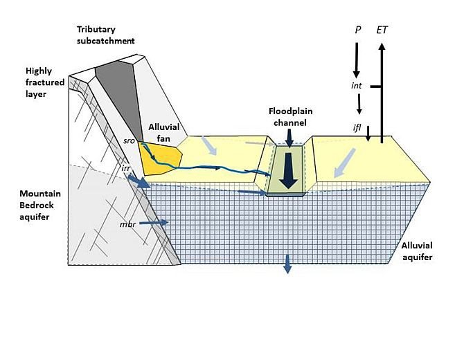
This indicates that much of the water recharging the floodplain aquifer from these storms flows from the mountains in the sub-surface. Furthermore, comparing thresholds of rainfall needed to initiate surface flows and flow peaks at the hillslope, tributary, and catchment scales also gives critical information about where and when surface and subsurface flows dominate catchment yields.
Monitoring and research in the Baviaanskloof is ongoing and is now informing a Water Research Commission-supported project to help catchment management in the region through collaboration with Living Lands, SAEON, the Department of Water and Sanitation, and other partners.
Further reading
- Clark, M.P., Slater, A.G., Rupp, D.E., Woods, R.A., Vrugt, J.A., Gupta, H.V., Wagener, T., and Hay, L.E. (2008). Framework for Understanding Structural Errors (FUSE): A modular framework to diagnose differences between hydrological models. Water Resour. Res. 44, W00B02.
- Glenday, J. (2015). Modeling the Hydrologic Impacts of Vegetation and Channel Network Change for a Semi-arid, Mountainous, Meso-scale Catchment: the Baviaanskloof, South Africa. PhD dissertation. University of California Santa Barbara.
- van Luijk, G., Cowling, R.M., Riksen, M.J.P.M., and Glenday, J. (2013). Hydrological implications of desertification: Degradation of South African semi-arid subtropical thicket. J. Arid Environ. 91, 14–21.
|
* The Professional Development Programme of the Department of Science and Technology and the National Research Foundation aims to accelerate the development of scientists and research professionals in key research areas.