
Integrating species distribution models and remote sensing to study fynbos
|


The conservation of biodiversity is largely dependent on an in-depth understanding of species distribution across landscapes.
In pursuing this knowledge, species distribution models (SDMs) have become popular tools in identifying suitable habitats, predicting future species distributions in response to environmental changes, investigating drivers of species distributions and testing ecological theories.
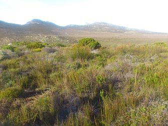
In my research I use SDMs to investigate drivers behind the distribution of fynbos species in the Cape Floristic Region (CFR). Of major concern is that the impacts of climate change on biodiversity may be amplified by climate-induced changes in fire regimes and vegetation growth rates, leading to alterations in species distributions and vegetation structure.
While fine-scale studies have given us much insight into the fire ecology of many fynbos species and the structure of the vegetation in which they commonly occur, the extent to which changes in the fire regime and post-fire vegetation growth rates may influence the occurrence of plant species across the CFR is unknown. More so, we do not know if the vegetation’s response to these changes in ecological regime varies across different species’ life histories.
We seek to address this knowledge gap by fitting SDMs with fire and vegetation growth information and examining their contribution in determining species distributions relative to climate and soils, taking note of differing growth forms or fire-response strategies.
|
Bringing remotely sensed data into SDMs
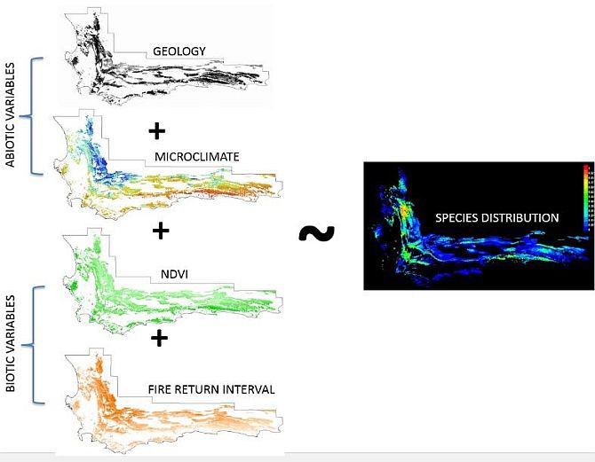
Most traditional SDMs are limited to the use of abiotic variables, such as climate and soils, and largely ignore other critical components of ecology that drive species distribution in the CFR. This reduces the sensitivity of the SDMs to underlying ecosystem interactions between species and their environment, thus limiting our understanding of how species distributions may be affected by changes in the environment and increasing our need for biotic variables in SDMs.
Advances in remote sensing have propelled us from simply mapping terrestrial features and objects through imagery to measuring various biophysical, biochemical and physiological elements of the environment, which we can now integrate into SDMs as biotic variables. In order to carry out this study, we incorporated both abiotic variables (such as climate and soils), which would be commonly found in a traditional SDM, and remotely sensed biotic variables (fire return interval and vegetation growth information), which are known to be critical drivers of species distributions in the CFR.
|
Challenges in integrating remotely sensed data into SDMs
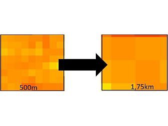
One of the requirements in modelling species distributions is that the predictor variables used as the input data must have the same spatial resolution.
In my study there were disparities in the spatial resolution between the remotely sensed biotic variables and the other variables derived from field observations and ground measurements. In order to address this issue, the resolution of the finer scale variables had to be upscaled to match that of the coarser variable, which resulted in the loss of some of the detail provided by the finer scale variables.
|
Other challenges that may arise when incorporating remotely sensed data into SDMs include limited availability of long-term remotely sensed data which can sufficiently describe ecological processes, as well as errors stemming from the acquisition, processing and analysis of the data. Combining both field data and remotely sensed data would serve well in providing longer records of data as well as improving the accuracy.
Other opportunities for remotely sensed data in SDMs
In acquiring the occurrence data for modelling the distribution of fynbos species for my study, I noticed that remote sensing may be useful in generating species occurrence data. Most SDMs require both presence and absence for the modelling process, however for our dataset only presence data were available (i.e. we only know where a species occurs but we do not know where it does not). We therefore used MaxEnt software to model the species as it only requires presence data and generates pseudo-absences as a proxy for the absence data. Unfortunately these pseudo-absences are not a real reflection of where species do not occur.
Sampling bias is another issue that was observed in our species occurrence dataset, and is quite common in distribution modelling since areas that are easily accessible are more sampled than less accessible areas.
Remote sensing offers the opportunity to overcome these drawbacks in species occurrence data by recording both the presence and absence of species at a lesser cost, in a shorter space of time and even in areas that are otherwise inaccessible.
The future of remote sensing and SDMs
The accuracy or performance of a SDM is only as good as the quality of data it is based on. Remote sensing has a part to play in the evolution of SDMs by supplementing ecological data that has been collected through field surveys and experiments.
How well SDMs and remote sensing will be integrated to pave the way for a new generation of SDMs will depend on a targeted and collaborative effort to acquire, develop and share information between ecologists, remote-sensing specialists and modellers. This, in turn, will enhance the performance of SDMs and enable us to better understand species distribution for the sake of conservation.
* Based at Stellenbosch University