
Changing the way…
|


|
South Africa has long been recognised for the diversity and beauty of its marine ecosystems, with a total of 2 798 km2 of coastline (excluding South Africa’s sovereign possession of the Prince Edward Island Group) and ranking 44th in the world (South African Navy Maritime Environment Report 2014).
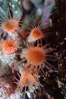
Sub-tidal rocky reef invertebrate communities in the warm-temperate Agulhas ecoregion of South Africa are not only some of the most beautiful in the world, but also some of the most under-studied.
My PhD research focuses on comparing the methods employed to study rocky-reef benthic invertebrates. This is being done in the hopes of changing the way that we, as marine ecologists, conduct research - in order to save time, money, necessary equipment, training, number of people needed... and did I mention, time and money? Sampling is expensive, and efficiency must be optimised.
Marine resources and ecosystems the world over are in peril, with varying combinations of habitat loss, habitat degradation, over-exploitation, and the cascading effects of climate change all driving what is proposed as the Anthropocene Age1 and the onset of a 6th mass extinction event.
Ecosystem-based management
Because our understanding of ecosystem functioning is based on the interaction between organisms and their environment, it is often much easier to manage and conserve areas by looking after the ecosystem as a whole, instead of trying to preserve one piece. The loss of biodiversity through extinction as a direct result of habitat perturbation can therefore be addressed by ecosystem-based management.
Biodiversity in marine ecosystems is not the same in all areas, and so not all areas can be managed in the same way. It is of vital importance to understand how organisms interact with their environment, so that conservation plans can be scaled into manageable parts.
Priority areas are those of high biodiversity, as these ecosystems support the largest number of species. The open ocean is lowest on the biodiversity scale in comparison to benthic ecosystems, and tropical to temperate reef systems score highest on the biodiversity scale. Therefore, much of our marine biodiversity can be found where reef areas exist in close proximity to coasts, and coasts are at the highest risk of biodiversity loss because of growing populations and increasing development. This means that these areas are of great importance in the race to study and protect as much of the ocean as we can.
Research methods
My research specifically targets the questions of how we study sub-tidal benthic habitats and communities. I focus on sessile invertebrate communities - they don’t run, swim or scuttle away when you get too close.
For comparison purposes, five different methods commonly employed by rocky-reef benthic ecologists are being studied. These methods range from uniform point counts, data collected with the use of a diving team, to photographic quadrats obtained with the Jump-camera system that is part of the SAEON benthic research platform.
The methods cover a broad spectrum of traditional and innovative techniques - from the logistically simple and relatively cheap extractive methods to the technologically advanced and complex. In addition, the quantity and scale of the data will be analysed, as some investigators may only require data that are large scale while others may be looking for data that provide species-level, fine-scale community patterns.
In other words, I could say that good data can be characterised by the number of users or investigators that can access it at whatever level of complexity that they require to answer their questions. Equally so, good methodology can be characterised not only by the “ease-of-use” factor, but also by the likelihood of the method to deliver what type of data an investigator is looking for.
Study site
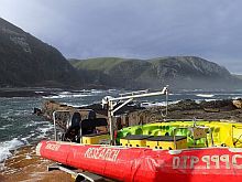
My study site is in Tsitsikamma National Park. Tucked away in the Eastern Cape and centred on Storms River Mouth is South Africa’s oldest marine protected area (MPA). This MPA has been in existence for over 40 years, and the Elwandle Node has been conducting long-term monitoring and methodological studies there.
The MPA has also been a no-take zone for many years, and thus represents one of the most historically important rocky reef complexes in South Africa, due to the protections afforded it, and therefore the community found in it. Tsitsikamma is an incredible place to work, and gives us a good idea of what healthy, functioning benthic ecosystems should look like, a baseline for future comparison.
The study site is a rocky reef complex that has both high- and low-profile reef, and covers sub-tidal depths from seven metres to approximately 50 metres. Sites are spread across the breadth and depth of the Rheeders Reef complex.
The Elwandle Node has been gathering data on benthic invertebrates since 2008. We finished collecting my thesis data in June 2015, giving us a long-term, multi-year data set perfect for repeated measure analysis that will allow us to optimise methodology, determine spatial patterns of invertebrate communities and also examine changes over time.
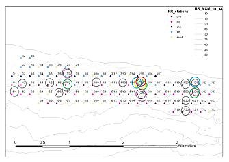
The figure above represents the Rheeders Reef complex. A grid system was overlaid to name our reference points. Each circle represents data collection at that site, 15 sites in total, and each different colour indicates a different year.
Lessons learned
Anyone who tells you that analysis and writing are the best parts of your PhD is probably not a field biologist. All of my data has officially been collected, and right now I am trapped in the analysis phase, which includes learning, making mistakes, and drinking lots of coffee, but hopefully not too much quiet weeping at my desk. Here are some preliminary results, as presented at the GSN Indibano:
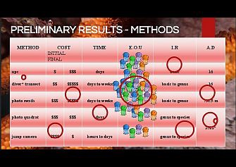
In the left-hand column you will see each method that was utilised to collect data. Along the top are the indices of comparison, and I have put together a very basic matrix to show how the methods are being compared in this preliminary stage.
Cost: The more dollar signs, the more expensive the method. Further divided into initial cost, the cost of equipment and final cost, which is the cost of use. The Jump camera system was fairly expensive to engineer, but has a long lifetime of use and is very cheap to operate. This is in comparison to a photo swath, which needs a diver to operate the camera. It has a lower initial cost than the Jump camera, but is the most expensive method to implement in terms of field work.
Time: Taking photo quadrats can be fairly quick, with a turnaround time of hours or days in the field. In comparison, using a diving team is expensive both in terms of money and time, and requires good weather windows (to be fair though, most field work requires good weather windows).
EOU: I call this the EASE OF USE index – how easy it is to learn how to use and then use each method. I’ve illustrated this with jellyfish. Swimming with just a few jellyfish is easy, and can even be enjoyable. However, finding yourself in the midst of a smack of jellies can be a painful experience, so again the photo swath method has the most jellies, and the lowest ease of use score.
IR: This the term that I use to describe INFORMATION RICHNESS, or the quality of the data collected by each method. Each method can give you basic data or very rich data, basic data being functional groups, or class data, while rich data may give you species-level information.
AD: ACTUAL DATA, or AD, column. We have to know what we are getting out of each method. For the purposes of my PhD, these are the actual numbers. Remember what I said about being trapped in analysis?
The asterisks indicate that none of these methods are truly free from constraints. Photos need to be analysed by someone. The time it takes to train a user in analysis is a constraint, as well as the time it takes to go through images. Divers have constraints. The Jump camera system is rated to 350 m, and while that falls outside of the sub-tidal region, it is important to mention in comparison to the 30 m max depth of divers.
Updated preliminary results - methods optimisation
Very soon I will be travelling to the 11th International Temperate Reef Symposium in Pisa, Italy, to present my first real concrete results. Since they have not been published, I can't tell you exactly what they are, but based on the optimisation study of one of the methods, there certainly is a better and more efficient way to analyse images of sub-tidal benthic communities.
With these data I hope to be able to suggest to the old-school that the new-school is cool too. My results show that one can indeed apply small changes in the way that one does something, and that can deliver savings in terms of time, and as everyone knows, time = money.
This streamlined approach will now help me to move on the next portion of analysis, which is looking at the spatial scales of the community itself. So it might sound strange that I spent the last six months figuring HOW to do something faster instead of just doing it, but it forms an integral part of my overall thesis, and supports the hypothesis that we can indeed improve on our current methodology.
Conclusions
There is a paucity of studies investigating which sampling methods are most suited to survey invertebrate communites in subtidal reefs in the Agulhas Ecoregion of South Africa, hence the need for my PhD research. My literature search has further revealed a lack of direction not only in terms of methodology, but also in how we look at the data obtained through that methodology.
Take a moment to remember the mandates of SAEON - to inform, to educate and to disseminate. My research occupies that place where all three overlap, so watch this space for the end of what I hope will be a beautiful story about changing the way we do marine science in South Africa.
1 Anthropocene is not an accepted geological term, but has been widely used in over 200 scientific papers, most recently in the journal Nature, published March 2015. The current debate seems to centre on when it started, not if.