
Drifter trajectories in the Agulhas Current - does it matter where they are deployed?
|


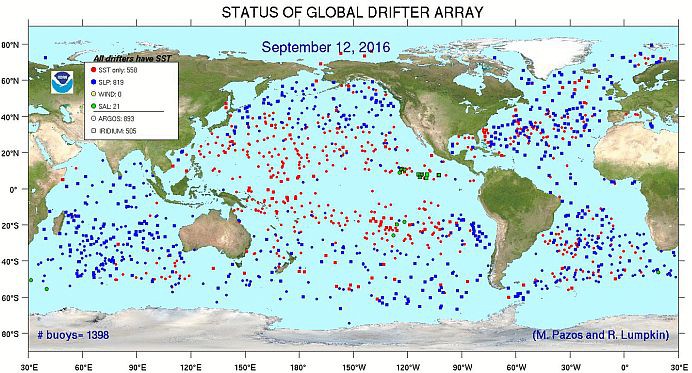
The Global Drifter Program is an array of surface drifters deployed and maintained by the international oceanographic community. This programme started in 1988 and has grown to a global array of 1 389 free-drifting surface buoys (Figure 1).
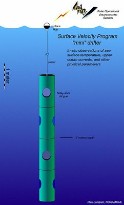
These buoys have a relatively simple design (Figure 2). They comprise a surface float with an antenna and a holey sock or drogue that hangs from it to capture the movements of the surface ocean currents. The buoys are tracked by satellites and send their location via the NOAA (National Oceanic and Atmospheric Administration) data centre every hour.
|
|
Using these satellite-tracked surface buoys, oceanographers are able to determine current speed and direction of surface ocean currents, as well as any other information from additional sensors the buoys are equipped with, such as sea surface temperature and atmospheric pressure. Due to the high frequency of data transmissions, the resolution of data is much higher than many other forms of lagrangian* instrumentation currently deployed (i.e. Argo floats).
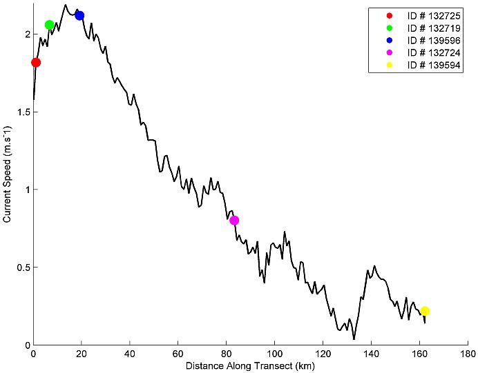
SAEON, in collaboration with the South African Weather Service (SAWS) and NOAA, deployed five surface drifters across the Agulhas Current during the second ASCA cruise earlier this year. Before the cruise these drifters were adopted by schools from the Egagasini education cluster around the Cape Peninsula as part of the Weather and Climate curriculum programme.
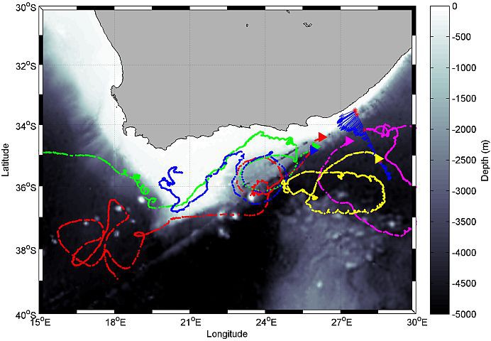
The deployments were targeted at key features of the Agulhas Current (core, outside edge and offshore) and all five were deployed within a few hours of each other. This was a repeat experiment from the first ASCA cruise a year earlier to test the hypothesis proposed by Blanke et al. (2009) who stated that a drifter deployed inshore of the Agulhas Current core has a higher probability of flowing into the South Atlantic than a drifter deployed offshore of the Agulhas Current core.
Preliminary results
Preliminary results from the 2016 deployments have shown that of the three surface drifters deployed inshore and within the core of the Agulhas Current, one propagated into the South Atlantic (green track, Figure 3), another was caught in the Agulhas Retroflection (red track, Figure 3), while the third was trapped on the Agulhas Bank (blue track, Figure 3). All three completed at least one rotation around a trapped cyclonic eddy on the eastern edge of the Agulhas Bank.
The two surface drifters deployed offshore of the Agulhas Current core (pink and yellow tracks, Figure 3) were almost immediately deflected into the Indian Ocean, with one returning to its deployment position and then continued propagating northwards.
|
Due to the high resolution of the data and the interesting trajectories of the drifters, the ASCA team were able to apply a method developed by Lumpkin (2016) to identify 'loopers' (looping trajectories that complete at least two rotations; Figure 4).
This work was prepared for the Data Buoy Cooperation Panel (DBCP) Workshop held at Scripps Institute of Oceanography in La Jolla, California in the United States of America on October 18th 2016. Scientists and technicians from around the world met at the workshop to discuss and share innovations and developments using satellite-tracked surface data buoys. ASCA presented a poster on this work.
Following the workshop, this work will be extended and published in a reputable peer-reviewed scientific journal.
* Lagrangian – is a way of looking at fluid motion where the observer follows an individual fluid parcel as it moves through space and time. Plotting this position through time gives the pathway/ trajectory of the fluid parcel (or in this case the surface drifter trajectory). Definition adapted from https://en.wikipedia.org/wiki/Lagrangian_and_Eulerian_specification_of_the_flow_field.
- Egagasini Node, South African Environmental Observation Network (SAEON), Cape Town, South Africa
- Marine Research Unit, SAWS, Cape Town, South Africa
- Oceanography Department, University of Cape Town, South Africa
- Regional Office (Western and Northern Cape), SAWS, Cape Town, South Africa