
Quantifying the water use of dominant land uses in the Maputaland Coastal Plain
|


|
Due to its unique hydrological system which is largely dependent on groundwater for the supply of water, the Maputaland Coastal plain makes for an interesting study area.
The dominant land use in the area is commercial forestry plantations of Pine and Eucalyptus species. These provide a significant source of income to the surrounding local communities.
This water-scarce system, located in northern KwaZulu-Natal, has in recent years seen a significant drop in groundwater levels which is thought to be caused by the surrounding commercial plantations of introduced species.
My master’s research under the supervision of Prof. Colin Everson, SAEON’s hydro-meteorologist, forms part of a broader Water Research Commission project which aims to understand and quantify the water use of different agricultural and ecological land-use components of the Maputaland Coastal Plain. Potentially, these components could be developed into (an) integrated, multiple-use agroforestry system(s) as an alternative to commercial plantation forestry in water-stressed catchments.
My research is focused on quantifying the water use of dominant land uses in the area at varying scales of observation.
Monitoring the water use of different plant communities
The research is being conducted at one of SAEON’s newly developed long-term monitoring sites, Vasi Pan, located between Lake Sibayi and Kosi Bay, northern Zululand.
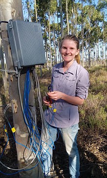
My work consists of long-term monitoring of the water use of the different plant communities at two spatial scales of observation - individual trees and entire plant canopies. The heat pulse velocity (HPV) technique is used to measure the water use (transpiration) of individual trees and eddy covariance (EC) systems are used to measure total evaporation of the dominant land uses in the Vasi Pan area.
At present a total of 18 trees are being monitored at five different sites. Species being monitored include Pines and Eucalyptus as they are the main commercial species in the area, and four locally abundant indigenous species (Figure 1).
These data provide us with important information on how much water each tree species is using daily and how these trees respond to environmental factors such as rainfall and incoming solar radiation. Some preliminary results indicated that this system is primarily limited by the availability of water, not energy.
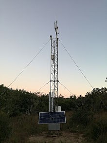
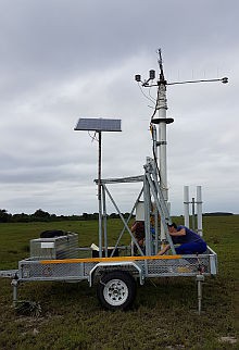
The EC system has a measurement fetch of approximately 100 m, making it ideal for monitoring total evaporation at a larger spatial scale. In the indigenous forest, an EC system has been placed which takes continuous measurements throughout the seasons (Figure 2), while a portable EC system is placed for two-to-four-week monitoring periods throughout the year in the different land uses (Figure 3).
Impact of varying land uses
The land uses being monitored are hygrophilous grasslands, indigenous forest and Pine plantations. This provides significant insight into the impact that the varying land uses are having on the available water resources, and can assist the team’s ecologist in his decision-making when assessing alternative agroforestry systems for the area.