
Smartfin – surfing for science
|


|
The surf zone is notoriously the most challenging environment for collecting physical and biogeochemical observations.
Features in the surf zone quickly become diluted or lost in and around breaking waves due to the huge momentum and mass transfer of the wave field.
Historically, therefore, there are very few observations in these regions around the world, yet daily surfers spend hours riding waves for pleasure and excitement.
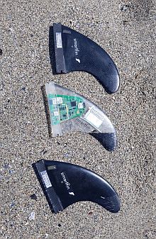
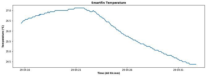
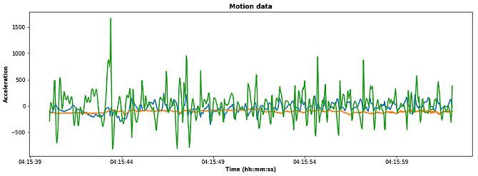
In collaboration with the Scripps Institution for Oceanography, the Surfrider Foundation developed Smartfin to overcome these challenges by using the surfers (or rather their surfboards) to collect a variety of data. Smartfin is a surfboard fin equipped with a range of sensors for the accurate measurement of seawater properties. Currently in its secondary development stage, the Smartfin is equipped with a temperature recorder, GPS, as well as an accelerometer.
The Smartfin is motion activated, so a simple shake of the surfboard wakes the fin up, finds a GPS position and starts collecting and recording data. The surfer then goes for a surf while the Smartfin collects data.
After the surf session the surfer will connect the fin to an inductive charger, which charges the fin back up and turns on a Bluetooth chip. Through an app on a smartphone, the data from the Smartfin can then be downloaded for the surfer and scientists to review (Figure 1).
Future versions of the Smartfin will be equipped with pH and salinity sensors, further expanding its capabilities.
|
Connecting the public with the ocean
The goal of the Smartfin project is to further connect the public with the ocean. We are aiming to do this by widely distributing Smartfins around South Africa. In this way, surfers will be able to actively monitor their local environment.
We will also be cultivating a society of citizens that are more aware of the changes in the environment. Given the abundance of data collected by the Smartfins, scientists are able to monitor coastal water quality, among other valuable research.
Monitoring the water quality in the surf zone is extremely important for both local marine biology and tourism. Many marine organisms live in the surf zone and are extremely susceptible to the quality of water in their environment.
Several beaches around South Africa pride themselves on having blue flag status. A requirement for this status is the continuous monitoring of water quality. This practice is costly and inefficient (samples may take days to analyse properly). Smartfin technology can significantly speed up this process while at the same time providing a larger spatial dataset.
In addition, the data collected from Smartfins could be used to validate coastal models and coastal satellite data and could thus be invaluable to coastal and shelf numerical models. The near-shore models would be able to use this data to validate wave dynamic predictions more accurately. In turn, the Smartfins can be validated against pre-existing sensors located at long-term monitoring sites such as Algoa Bay and False Bay.
If you are interested or would like to get involved in the Smartfin project, please contact Jethan.