
What’s causing the water levels in South Africa’s largest freshwater lake to drop?
|


uMhlabuyalingana means “the area that is flat”, an apt name for this local municipality nuzzled in the northern coastal corner of Maputoland in KwaZulu-Natal.
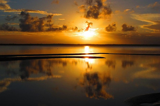
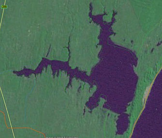
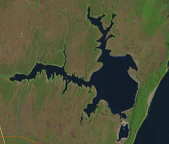
Within this local municipality lies Lake Sibayi, a freshwater lake with a surface area of some 64 km².
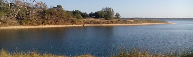
I first started taking photos of a section of the lake in 2014. Back then there was already concern about the decline in the water table in the region, and this has escalated over the ensuing four years. The current situation provides a focal research opportunity to understand the relative impacts of land-use, water abstraction, weather, climate change and sea-level change on an important coastal aquifer system in South Africa.
The treasure that is Maputaland
The Maputaland Coastal Plain is imbued with a rich biodiversity and the promise of adventure. The South African section extends across a band of about 70 km wide in the north, bordered by Mozambique, to a narrow area in the south at the mouth of the St Lucia estuary. The Lebombo Mountain range forms the western boundary of this low-lying coastal plain.
|
Heading south from Kosi Bay in the north, tourists can visit Banganek, Black Rock and M’bibi, each a relatively unspoilt coastal paradise (for those who have a 4x4). Next to the coastal dunes, opposite M’bibi, lies Lake Sibayi (also spelled Sibhayi), which forms an integral part of an extensive wetland system. South of that lies Sodwana Bay, which offers some of the most phenomenal coral reef scuba diving in the world.
If you are interested in wildlife, you can dive in the morning and be sipping sundowners watching elephants in Tembe Elephant Park in the afternoon. If you are looking for spectacular birds, Mkuzi is just down the road and further south is the well-known Lake St Lucia. Several protected areas in the region have been consolidated into the iconic iSimangaliso Wetland Park, which has been proclaimed a World Heritage Site.
How did the Maputaland coastal plain form?
In simple terms: over geological time the area was subject to fluctuations in sea level, resulting in marine, alluvium and aeolian deposits over the underlying cretaceous layer. Porat and Botha (2008) provide a detailed temporal framework, as well as postulating underlying processes associated with the series deposits and dune formations from the late Middle Pleistocene to the Holocene.
These dune formations are associated with global glacial/interglacial climatic cycles and sea-level influences. At a very basic level, the coastal plain is comprised of porous sandy material, underlain by a relatively impermeable cretaceous layer. This results in a perched water table.
The interdune depressions are therefore rich in wetlands and peatlands where the topography intersects with the water table. The region is also host to southern Africa’s largest estuary (St Lucia) as well as a series of freshwater lakes including Lake Sibayi, the largest natural lake in South Africa.
A rich wetland system in a mosaic of grassland and forest
The low-lying topography in the coastal plains means that the groundwater is generally close to the topographical surface, which creates a shallow phreatic zone that strongly influences the terrestrial ecology. Many studies have shown that the groundwater is one of the key ecosystem drivers in the Maputaland coastal areas as has been particularly demonstrated for the St Lucia system (Rawlins, 1991; Taylor, 2006; Taylor et al., 2006; Kelbe et al., 2013).
Changes in groundwater dynamics at a regional scale will consequently have impacts for both the wetland and the terrestrial systems. The vegetation is a rich mosaic of different grassland, forest, savanna and thicket communities and hosts a high number of endemics.
|
Is this rich wetland system under threat?
Given the size and importance of the region’s groundwater aquifer, it recognised as one of South Africa’s strategic groundwater areas. Over time, however, the region has been subject to a number of environmental impacts, including changes in land-use, alteration of catchment river hydrology, mining and potentially also changes in climate in more recent years.
Of further significance is the rich cultural history of the region and current socio-political dynamics. The history of the area is relatively well-documented and supported by a rich body of science spanning multiple disciplines. Significant focal attention in relation to this dynamic has been centred on Lake St Lucia.
Historically, portions of the area fell under the Department of Forestry and Fisheries (DAFF), with several plantations developed on the coastal plain. In 1971 Tinley produced a report focusing on the St Lucia system. He highlighted the importance of the fresh groundwater contribution to the health of the lake and raised concern over the potential impact of the plantations (initiated on the eastern shores in 1963) on the groundwater resources feeding the system. Plantations on the eastern shores of Lake St Lucia were subsequently removed.
The relative impact of climate and management, such as the pine plantation removal, was assessed by Varet et al. (2009), who demonstrated, through modelling, that the act of removing the plantations had a positive impact on the groundwater table in the eastern shores section of the reserve. Their work highlighted the impact of land-use as well as climate on the groundwater resource.
Research and long-term data sets provide foundation for global change observation
As a direct result of the Tinley report, a groundwater monitoring programme was initiated on the eastern shores in 1973 under the St Lucia Scientific Advisory Council (SCADCO). This monitoring programme has been continued to date by Ezemvelo KZN Wildlife, providing an invaluable record of over 40 years’ monthly readings from monitoring wells.
In the interim, concern started emerging in 2011 regarding the decline in the groundwater table in the area north of Lake St Lucia between Mbazwane and Khozi Bay (pers. comm. M Schapers, 2011). More recently several studies have focused on the Sibayi system (Weitz and Demlie, 2014; Smithers et al., 2017). These have provided indications that land-use, particularly forestry, in combination with an extended drought, may be having a significant and potentially unsustainable impact on the system, although there is some debate regarding the severity of the impacts.
Given the rich science history of the region, and availability of selected long-term data sets, the SAEON Grasslands-Forests-Wetlands Node has sought to develop a programme aimed at enabling continued efforts to understand the relative impact of land-use and climate on the ecology and water resources of this area at a regional scale. There is a very real need to provide economic opportunity in the region, particularly in the north where poverty levels are high. Major initiatives are afoot to reignite forestry in the northern part of the region, amid growing concerns related to the water sustainability of such a programme.
In 2013, the node initiated a complementary monitoring programme to collect finer-scale data to what was being collected on the eastern shores by Ezemvelo KZN Wildlife. Our ultimate aim is to develop a regional monitoring network.
Over time, working with several collaborators including the Department of Water and Sanitation, commercial forestry and scientists active in the area, we expanded our activities into the northern section of the coastal plain at a very basic supportive level. From 2014 onwards, we provided logistical support to a Water Research Commission (WRC) project aimed at assessing the hydrodynamics of the Sodwana Bay system. The project is run by Prof. Bruce Kelbe, Prof. Guy Bate and Dr Ricky Taylor, who produce a valuable assessment of ecology and hydrodynamics of that sub-catchment as an excellent baseline.
In 2015 node staff started working in the Vazi pans area, within catchment W70A in the Umhlabuyalinga local municipality. This catchment includes Lake Sibayi, the Vazi wetland system and Kosi Bay in the north. The work around Vazi pans was facilitated through a WRC project run by SAEON’s Prof. Colin Everson, which focuses on understanding alternative agroforestry systems and plant water use.
By 2016, node staff had deployed a groundwater monitoring system in the Vazi wetlands. In 2017, with funding from the Natural Resource Management programme of the Department of Environmental Affairs, a number of monitoring wells were upgraded. Over this time, a continuing decline was observed in the water levels of Lake Sibayi as well as groundwater levels in this northern region.
|
Seeking guidance and stakeholder input
In May 2017, I called an informal meeting inviting experts in groundwater modelling who had insight into the Sodwana-Sibayi-Vazi-Kosi systems, including experts from the Department of Water and Sanitation (DWS). The intention was to determine if there was consensus of what might be happening in the system and if there was a case for solid long-term observation by SAEON in the area.
What emerged was confirmation that the area offers an ideal opportunity to tease global change impacts by understating the relative contributions of climate, land-use, water abstraction and sea-level interactions on one of South Africa’s key groundwater aquifers. There is a paucity of research-focused observation data within the system. Some key long-term data sets had recently been compromised and some critical data gaps (that are logistically difficult for university researchers to address) were identified. SAEON, as a platform provisioning institution of the National Research Foundation, seems well positioned to address these issues.
Given that Lake Sibayi is an expression of the regional groundwater table, two immediate priorities were identified: data on the current level of the lake were unavailable as all monitoring stations are situated high and dry above the declining water table; and many of the monitoring wells had not been surveyed into mean sea level.
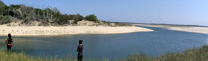
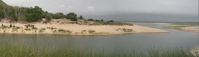
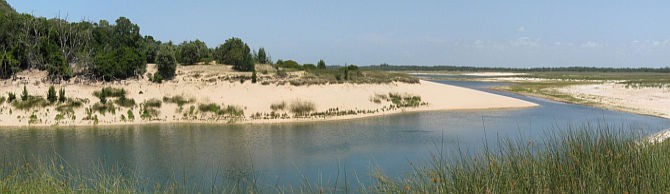
After the photo I took in 2014, the next time I visited the area there was a land bridge between the small southern basin and the large lake. Repeat visits left me with the sense that the two lakes were at distinctly different levels. This is something I felt should be checked.
With the permission of iSimangaliso Wetland Park, node staff were able to put temporary systems in place to monitor the lake level. In collaboration with DWS we also managed to survey in and set markers for many of the monitoring wells in the area and the lake edges, in several positions.
When full, the lake is about 20-22 m above mean sea level and has a maximum depth of 40 m. The result of the survey confirmed that the two lakes were now at different levels. At the time of measuring (November 2017), the large lake was at 14,8 m above mean sea level and the smaller lake was only 8,4 m above sea level. January readings indicate a continued decline in levels despite some rain in the area. The previous known record low for the lake was 17,1 m above mean sea level in around 1970/71.
The unique case of catchment W70A?
After studying the region’s maps, I realised that unlike the St Lucia system, catchment W70A has no surface rivers flowing into it. This means the system is very dependent on rainfall.
In order to inform land-use policy we therefore need clear predictions on future precipitation trends as so much hinges on these in terms of water sustainability. The area gets its rain from frontal systems, thunder storms and cyclones. At this stage such predictions are too uncertain.
But something else was bothering me. While the St Lucia area seems to be receiving good rains, my observation has been that the area north of Mbazwane does not seem to be receiving as much. However, rainfall data are very limited for this section, something we aim to address.
Prof. Ross Blamey of the University of Cape Town explained to me that the Mascarene high located in the middle of the South Indian Ocean can bring in moisture, but the moisture needs something to lift it before it rains. Recall again the name uMhlabuyalingana. If the high moves too close to the coastline it may suppress convection, particularly in flatter areas, despite moisture being available. This is an oversimplification, but it offers some indication of why we need to improve predictions for this area in terms of precipitation.
|
Key ingredients for moving forward: Community buy-in and multi-institutional and multidisciplinary collaboration
In a recent SAEON eNews, MD Johan Pauw highlighted some of the work of Daniel Orenstein that alludes to why, as ecologists, we may not be good at influencing policy or getting traction in implementing our research findings. Johan also reported from the 2017 ILTER meeting held in France: “The notion that it is important to understand why humans do what they do was also put forward as a global research question in relation to SES (Social-Ecological Systems).”
Catchment W70A falls within Ingonyama trust land. The area has some of the highest poverty levels in the country, education and skills development are low and basic infrastructure is still largely lacking. Here people’s lives are far more tightly intertwined with natural systems than those of us who live in cities. The soils are poor for agriculture and there seem to be limited options for economic growth.
It is therefore imperative when initiating work in the area to ensure there is community buy-in at the outset. The socio-economic context and concern regarding the potential impacts of alternative land uses such as forestry, which many see as the only sources of income, in my view necessitates a multi-disciplinary collaborative approach if we are to see traction in response to our work.
To this end SAEON, in collaboration with the Isibusiso Esihle Science Discovery Centre (a home-grown science centre close to Vazi pans), hosted an informal workshop inviting relevant stakeholders and interested experts from different disciplines including hydrology, sustainability, resources economics and horticulture. The workshop started by listening to the voices of community members and industry operating in the area. There was unanimous concern regarding the perceived decline in the water table and the role that plantations may be playing in this in conjunction with the drought.
The main request was for scientists to work together with industry and community members to understand trends, but more importantly, to provide guidance on alternatives: “We know there is a problem, but we cannot remove the trees without alternatives being in place. Please work with us to find alternatives.”
Thereafter various scientists gave feedback on their work in the area, confirming some of the perspectives but also highlighting the need for a better understanding of the relative impacts of climate change and land-use. Prof. Danny Simatele from the University of the Witwatersrand, who was invited for his expertise in sustainability and helping to move communities forward, ended the day as if in response to pleas for alternatives by providing a roadmap of how this could be realised.The net result was a consolidated group of individuals, institutions and community members who are now interested in working together collectively to perform context-relevant research across different, but complementary fields. The vision is that this will hopefully be of direct benefit to the region and the people who depend on it.
SAEON Grasslands-Forests-Wetlands Node scientists feel we can now comfortably move forward with developing a longer-term presence for environmental observation in the area, knowing there will be collaborative support from disciplines outside of our field of expertise who can work with the communities and industry in the area to seek sustainable livelihoods in a changing world.
Hopefully this will lead to better traction in translating findings into policy.
Further reading
- Kelbe, B, Taylor, R and Haldorsen, S. 2013. Groundwater hydrology. In: Perissinotto, R, Stretch, D and Taylor, R (eds). 2013. Ecology and Conservation of Estuarine Ecosystems: Lake St Lucia as a Global Model. Cambridge University Press.
- Porata, N and Botha, G. 2008. The luminescence chronology of dune development on the Maputaland coastal plain, southeast Africa. Quaternary Science Reviews 27: 1024–1046.
- Rawlins, BK. 1991. A Geohydrological assessment of the behaviour and response of the Zululand coastal plain to both environmental influences and human activity. Unpublished MSc dissertation submitted to the University of Zululand, January 1991. 150 pages.
- Taylor, R. 2006. Ecological responses to changes in the physical environment of the St Lucia Estuary. Dr. Scient. Thesis, Norwegian University of Life Sciences, Aas, Norway.
- Taylor, R, Kelbe, B, Haldorsen, S, Botha, G, Wejden, B, Været, L & Simonsen, M. 2006. Groundwater-dependent ecology of the shoreline of the sub-tropical Lake St Lucia. Environmental Geology 49: 586-600
- Tinley, KL. 1971. Lake St Lucia and its peripheral sand catchment: the ecology and implications of proposals to reprieve a condemned system. Wildlife Society of Southern Africa, Johannesburg.