
What makes the South-East Madagascar Bloom so intriguing?
|


|

The South-East Madagascar Phytoplankton Bloom is one of the largest blooms in the world, covering an area of approximately 2 million km2.
It occurs in a low-productivity region south-east of Madagascar in austral summer, but not every year.
These microscopic plants are fundamental in regulating the carbon dioxide (CO2) in the atmosphere by taking it up during photosynthesis. The absorbed CO2 is then dropped to the bottom of the sea.
The bloom is also important as phytoplankton forms the base of the marine food web. Since it occurs in the exclusive economic zone of the surrounding islands (Madagascar, Reunion Island and Mauritius), it can support fisheries in the region and hence contributes to the fishing industry of these islands.
This bloom has aroused the interest of many scientists since its discovery in 2001. The goal of my PhD was to better understand the drivers controlling it. These are critical to provide a better insight into the health of the surrounding marine ecosystems, as well as their associated oceanic carbon cycles.
|
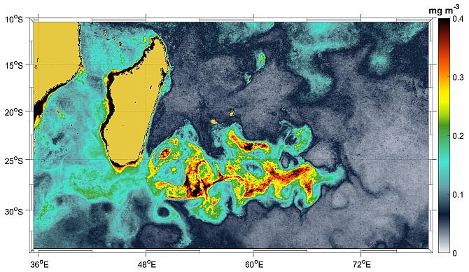
An upwelling region is present in the south of Madagascar, where nutrient-rich waters are brought from the subsurface to the surface, contributing to primary production. This upwelling is controlled by the neighbouring current, the South-East Madagascar Current (SEMC), which flows poleward along the eastern coast of Madagascar.
Most previous studies have associated the occurrence of the bloom with an increase in nutrients coming from the deeper levels (increased upwelling). In our study we show that the input of nutrients in the surface levels is reduced when the bloom occurs. This is counter-intuitive and in clear contradiction with what has been hypothesised before.
We also show that the bloom co-occurs with the La Niña climate phenomenon. La Niña is associated with cooler-than-average sea surface temperatures in the central and eastern tropical Pacific Ocean and is known to influence the global climate. Wind patterns and intensities of oceanic currents in the Indian Ocean vary during this event.
The SEMC is stronger during La Niña, and a stronger SEMC will favour an early detachment of the current from the coast. This new path of the SEMC will bring coastal waters, usually rich in nutrients, into the bloom region. These nutrients will be consumed by phytoplankton, through photosynthesis, inducing an increase in production. Hence, south of Madagascar, the current will be weakened, reducing the upwelling intensity. This agrees with our findings.
This new finding is tested in the modelling world using a high-resolution physical-biogeochemical model. The various analyses indicate that indeed, nutrients can be transported from the very nutrient-rich coastal waters. This would occur due to an early detachment of the SEMC from the coast.
Another factor which can also cause the bloom would be the influence of winds on the ocean. The winds would cause mixing, which will bring deeper water with a high concentration of nutrients into the surface levels, initiating a bloom.
|
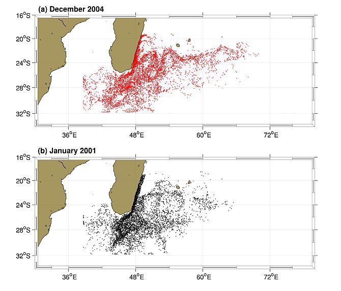
Releasing particles on the eastern coast of Madagascar and allowing them to drift through the surface oceanic circulation confirms that coastal waters are brought into the bloom region when the bloom occurs. On the contrary, when the coastal waters are transported southward, no bloom occurs.
The main finding of our study is that the southern part of Madagascar acts as a gate for the water to either flow westward towards the Agulhas Current and hence there is no bloom, or for the water to flow eastward in the bloom region, causing the bloom. With this finding we have unveiled a new feature of the SEMC that was previously unknown. In some cases, the SEMC can detach from the Madagascan coast flow eastward, south-eastward.
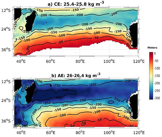
South Indian Ocean Eddies (SIDDIES)
Eddies in the ocean are very important as they are vectors of water masses as well as nutrients and trace elements. In the Indian Ocean, eddies exist in two forms, apart from cyclonic and anticyclonic. The first of these is an eddy with its core at the surface and the second, an eddy with its core in the subsurface layers.
Previously identified only in the south-western Indian Ocean, our study shows that these two types of eddy occur across the South Indian Ocean Basin. They are formed west of Australia and travel all the way to Madagascar. The band along which they travel has been termed “SIDDIES Corridor”.
During their long journey, they have been shown to transport significant water masses, which can contribute towards the net global heat/salt budgets. This is important as the net global heat/salt budgets control the mean oceanic circulation around the globe.
|
After PhD
This PhD has been an exciting journey. The end of it also marks the end of my fabulous five years in Cape Town. Next stop is GEOMAR Helmholtz Centre for Ocean Research in Kiel, Germany, where I will be starting a postdoctoral in October. My research will shift from the Indian Ocean to the Eastern Tropical North Atlantic, but I will still be working with eddies and their potential influence with Oxygen Minimum Zones, using both observational datasets and the ocean models.