
Steps forward (and upward) with EFTEON
|


As part of the South African research infrastructure of the future, the Expanded Terrestrial and Freshwater Environmental Observation Network (EFTEON) is focused on monitoring social-ecological systems and integrating scientific observations of the social, biological and physical environment into policy- and decision-making.
To initiate this process, EFTEON is engaging with scientific stakeholders and existing research facilities to enhance collaboration and promote the development of expertise around research infrastructure.
Lessons from two eddy covariance flux towers
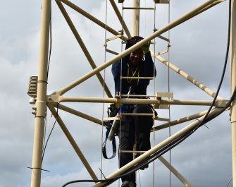
In April 2019, EFTEON members joined the CSIR on a site visit to the Skukuza and Agincourt flux towers in Mpumalanga to share in the experience of eddy covariance flux tower usage, maintenance and management. For some the site visit was a return to old stomping grounds and long forgotten fieldwork intricacies, while for others it was the first time seeing, not to mention climbing, a flux tower (below).
|
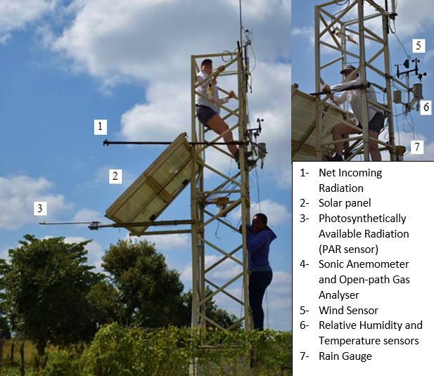
Flux towers are structures from which meteorological instruments measure landscape-level productivity, respiration and changes in the water and energy balance between the landscape and atmosphere using the eddy covariance (EC) technique. The flux towers consist of highly specialised equipment to measure and collect data continuously from the environment. The instruments record atmospheric conditions multiple times per second and average across 30-minute intervals to generate meaningful CO2 and H2O concentrations.
High-resolution atmospheric data
The EC systems measure atmospheric turbidity, incoming and outgoing radiation and weather conditions to aid scientists in quantifying changes in the landscape over time, comparing energy fluxes across different landscapes and identifying Carbon sinks and sources. These systems offer high-resolution atmospheric data which is applicable for researchers and data scientists across a multitude of disciplines.
Visiting the CSIR flux tower sites introduced a sense of awe and respect for scientists and technicians involved with the flux tower systems. Apart from getting to grips with being suspended at heights while performing maintenance and data collections, the eddy covariance technique is based on an intimidating combination of meteorological and physics-intensive theorems which depend on atmospheric turbidity to measure local ecosystem respiration.
The Agincourt flux tower (above) is six metres tall and was erected in 2016. The tower is located on the periphery of a rural settlement east of Bushbuckridge and is unique in that it informs scientists about the impacts of a rural settlement on landscape energy fluxes.
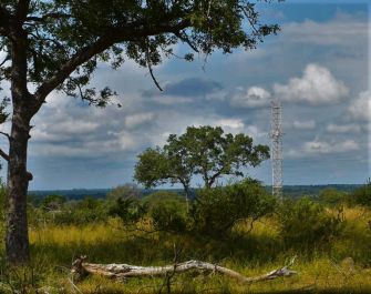
The Skukuza flux tower (below) is 22 metres tall and was erected in 2000, making it the longest flux dataset for Africa. The tower is located along the ecotone within a catena sequence in the Kruger National Park. The Skukuza tower records eddy covariance data about the upslope, broadleaf savanna and downslope, fine-leaf savanna which seem to show little difference in terms of energy flux or Carbon sequestration abilities.
|
These eddy covariance flux towers provide a unique opportunity for South Africa to contribute valuable data from the Kruger National Park savanna site, an under-represented vegetation type in eddy covariance flux observations, and the nearby rural community landscape which can be used to inform land-use policy and decision-making processes across Africa.
Flux data from the Agincourt and Skukuza towers, along with data from another tower located further north within the Kruger National Park (Malopeni), are part of ongoing studies into landscape change and sequestration potential at the CSIR. These data and a suite of more recently established eddy covariance flux towers are readily available via FLUXNET and the CSIR.
A special thank you goes to the CSIR for facilitating the site visit and to Gregor Feig, Humbelani Thenga and Graham von Maltitz for sharing their expertise and skills.