
Looking under the hood of hydrological models
|


Recent droughts and water shortages across South Africa have increased public awareness of the rivers, reservoirs and groundwater aquifers that cities, towns and communities use for water supply.
Have you ever wondered how the capacities of these resources are estimated?
To help manage water resources and maintain healthy ecosystems, hydrologists need to make predictions about how much water there will be in rivers and aquifers over time, given varying climate conditions over seasons and years.
It has become standard practice to do this using hydrological models of catchment areas. There are a wide variety of different modelling strategies and tools to choose from, each having its own benefits and limitations.
|
In view of this, SAEON recently started work on a collaborative research project funded by the Water Research Commission (WRC) to explore the similarities and differences between several catchment hydrological models and tools that are commonly used in South Africa. The project aims to look at the implications of applying different models in different settings and provide guidance for modellers.
The two-year project, “Critical catchment hydrological model inter-comparison and model use guidance development” (K5-2927), is being led by postdoctoral researcher Dr Julia Glenday at the SAEON Fynbos Node. The project team includes collaborators from the University of Cape Town, University of the Western Cape, Stellenbosch University, Rhodes University and the University of KwaZulu-Natal (UKZN), as well as several environmental consultancies.
Numerical models of catchment hydrology: climate + catchment = streamflow
Catchment hydrological models can be extremely useful tools for water resources management. Given inputs of rainfall, other climate variables that influence evaporation and plant water use (temperature, humidity, wind, etc.), and biophysical information about a catchment area (topography, land cover, soil properties, etc.), these models output predictions of streamflow, and, in some cases, groundwater storage.
|
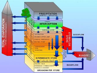
Sets of equations and logic statements are used to calculate estimates of how much of the rainfall will be caught on leaves or reach soil, rock or paved surfaces; how much will run off the surface to a stream or infiltrate into soil; how much will evaporate or be used by plants; how much will move downwards and recharge groundwater aquifers; and how much water in the subsurface will flow out into streams.
Models can include representations of human activities, such as groundwater pumping and irrigation of crops. They can be used for a wide range of applications, such as predicting how climate change or land use change may impact future water resources.
The outputs of these models help inform management decisions, such as the quantity of water that can be allocated to users from a supply system, which areas should be excluded from development due to high flood risk, or which areas should be prioritised for alien vegetation clearing to increase water availability. Modelling and observational data go hand in hand. Earth observation data is needed for the model inputs, such as climate and landcover data. In addition, model outputs need to be tested against observational data to understand how reliable their predictions about the future are likely to be.
Hydrological models are simplified approximations of the many processes and flows that occur in a catchment and their predictions will always be uncertain. In addition to testing models, earth observation data is needed as model inputs in the first place. The field environmental monitoring work of SAEON and other institutions is therefore critical for the use and ongoing development of modelling tools.
Hydrology researchers globally, and in South Africa, have come up with a number of strategies for modelling catchment hydrological processes and have coded the calculation methods into software programmes. There are many hydrological modelling software tools currently available, each of which calculates things in somewhat different ways. Many of these tools undergo continual testing and improvement.
Models can differ in terms of how they break up the catchment area into different units, such as patches of different land cover types or topography, different soil layers, different aquifer types, and how these units can be linked. They differ in the exact equations that are used to estimate the flows within and between these units.
Often models were initially designed and tested in particular settings, such as a snow-dominated region or a monsoon region, and sometimes with particular purposes in mind, such as predicting long-term average water supplies to reservoirs in data-scarce environments or flood prediction in data-rich settings.
Over time some have been adapted to be more widely applicable. Someone who wishes to use a catchment hydrological model for a certain application needs to decide which modelling tool to use and how best to use it; or start from scratch and code their own.
Collaborative model “test drives” in different settings across South Africa
The WRC model guidance project will focus on four catchment modelling tools that are already being used in the South African water sector. These are the:
- ACRU (Agricultural Catchment Research Unit) modelling system (Schulze, 1986, 1995);
- Pitman model (Pitman, 1973) versions available in the WRSM (Water Resources System Model) tool (Bailey and Pitman, 2015) and in the SPATSIM (SPAtial and Time Series Information Modelling) tool (Hughes, 2004, 2005);
- SWAT (Soil and Water Assessment Tool) modelling system (Arnold et al., 1998; Neitsch et al., 2011); and
- MIKE-SHE (Système Hydrologique Européen) modelling system (Abbott et al., 1986; DHI, 2014; Refsgaard and Knudsen, 1996).
The ACRU and Pitman modelling tools were developed at South African universities (UKZN, Wits University and Rhodes University) and are the most widely used in the country. SWAT originates from the United States and MIKE-SHE from Europe, but both are used globally and in South African research and applied contexts.
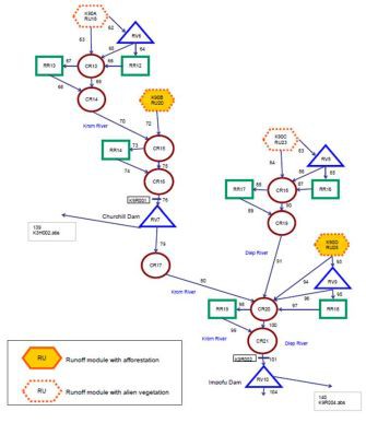
These tools differ in several respects including spatial and land cover unit options, representation of processes and time-steps of calculation. For example, the Pitman model was designed to run on a monthly time-step, while the other tools run on daily or smaller time-steps. MIKE-SHE software allows a modeller to break up the catchment area into grid cells and calculate the water movement within and between each cell. The other tools can model the catchment area as different patches of land cover types and/or topographic units, like hillslopes and floodplains.
Models with finer spatial, temporal and process resolution can help to answer certain types of questions and assist in highly diverse catchment areas. However, they also require more input data and computing power to run and the uncertainty in the outputs can be harder to determine and to address.
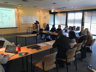
Workshop
The project recently kicked off with a workshop (15 August 2019 at SAEON's Fynbos Node) to discuss the approach to inter-comparison and what kind of guidance information would be helpful to promote wise use of modelling tools. It was attended by the project team and modelling experts, including some of the original developers of the South African modelling tools themselves.
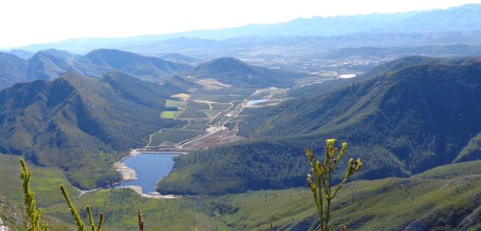
The project team will use all the modelling tools to model a set of case-study catchment areas, including parts of the Berg River catchment in the Western Cape, the Kromme River catchment in the Eastern Cape, the uMgeni River catchment in KwaZulu-Natal, and the Letaba River in Limpopo. These areas represent a diversity of climatic, geological, topographic and ecological settings.
In addition, different scenarios of change will be considered, such as the influence of invasive alien plants, irrigation and groundwater withdrawals. The process of representing the catchments and the scenarios with the modelling tool, the accuracy of the output compared with observational data, and the changes in the water balance predicted under the scenarios will be assessed and compared across the tools.
The experience gained in this process, and with consultation with other modellers and experts, will be used to create guidance material for future modellers to assist in applying modelling tools in different contexts.
If you are a hydrological modeller and are interested in getting involved in this project, please contact Julia Glenday.
Further reading
Abbott, M.B., Bathurst, J.C., Cunge, J.A., O’Connell, P.E. and Rasmussen, J. (1986). An introduction to the European Hydrological System — Systeme Hydrologique Europeen, “SHE”, 1: History and philosophy of a physically-based, distributed modelling system. Journal of Hydrology 87, 45–59.
Arnold, J.G., Srinivasan, R., Muttiah, R.S. and Williams, J.R. (1998). Large area hydrologic modeling and assessment - Part 1: Model development. J. Am. Water Resour. Assoc. 34, 73–89.
Bailey, A.K. and Pitman, W.V. (2015). Water Resources of South Africa 2012 Study (WR2012) - Version 1 (Pretoria, South Africa: Water Research Commission (WRC)).
DHI (2014). MIKE SHE User Manual, Volume 2: Reference Guide (Hørsholm, Denmark: Danish Hydrologic Institute (DHI)).
Hughes, D.A. (2004). Incorporating groundwater recharge and discharge functions into an existing monthly rainfall–runoff model/Incorporation de fonctions de recharge et de vidange superficielle de nappes au sein d’un modèle pluie-débit mensuel existant. Hydrological Sciences Journal 49, null-311.
Hughes, D.A. (2005). SPATSIM, an Integrating Framework for Ecological Reserve Determination and Implementation (Gezina, Pretoria, South Africa: Water Research Commission (WRC) & Rhodes University).
Neitsch, S.L., Arnold, J.G., Kiniry, J.R. and Williams, J.R. (2011). Soil and Water Assessment Tool (SWAT) Theoretical Documentation, Version 2009 (College Station, Texas, USA: Texas Water Resources Institute, Texas A&M University).
Pitman, W.V. (1973). A mathematical model for generating monthly river flows from meteorological data in South Africa (Johannesburg, South Africa: Hydrological Research Unit, University of Witwatersrand).
Refsgaard, J.C. and Knudsen, J. (1996). Operational Validation and Intercomparison of Different Types of Hydrological Models. Water Resources Research 32, 2189–2202.
Schulze, R.E. (1986). The ACRU model for agrohydrological decision-making: structure, options and application. In Proceedings of the Second South African National Hydrology Symposium (Pietermaritzburg, South Africa: Department of Agriculture and Engineering, University of Natal.
Schulze, R.E. (1995). Hydrology and Agrohydrology: A Text to Accompany the ACRU 3.00 Agrohydrological Modelling System (Pretoria, South Africa: Water Research Commission (WRC)).