
In a flood (of tears) for the lost riparian woodlands of the Lowveld
|


The rivers of the Lowveld are the lifeblood of the landscape, transporting water, sediments and nutrients from the escarpment and surrounding landscape, which become the important resources that sustain critical aquatic and riparian habitats.
Riparian vegetation differs markedly from upland areas, particularly in winter, with brown savanna giving way to lush, year-round greenery.
Magnificent jackalberry (Diospyros mispeliformis), sycamore fig (Ficus sycamorus) and nyala tree (Xanthacercus zambeziaca) specimens, to name a few, are supported in this transition zone between aquatic and savanna realms. Plants here are able to withstand the high water table and accumulation of nutrients associated with riverbanks. Indeed, many of the Lowveld’s riparian woodlands are so unique that they are classified as distinct vegetation units (i.e. Subtropical Alluvial Forest and Lowveld Riverine Forest).
These riparian zones range from as little as 10 m in width to over 250 m wide along some parts of the Sabie and Luvuvhu Rivers in the Kruger National Park (KNP). This riparian vegetation fulfils important ecological functions such as the trapping of pollutants, regulating river flow and buffering against floods, and providing habitat, shade and forage. Riparian ecosystems are also culturally and recreationally (and so financially) important.
Riparian woodlands are decreasing
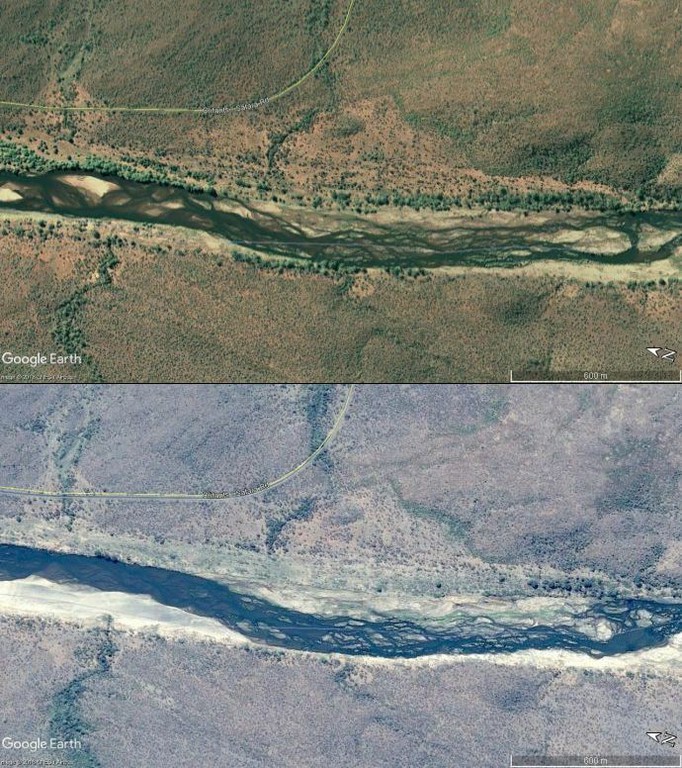
Verbal accounts supported by limited ground-based and satellite images, reveal decreasing riparian woodland and a loss of large trees along the rivers of KNP, and elsewhere, over the last century (Figure 1). An earlier SAEON study also showed dramatic reduction in Greefswald (riparian) Forest in Mapungubwe National Park .
Studies conducted on rivers elsewhere in the country have revealed riparian woodland losses driven by water abstraction, removal of vegetation to make way for cultivation, and elephant damage. Little research has focused on riparian woodland dynamics either in or out of protected areas, perhaps because these habitats represent only a tiny fraction of the land surface area.
Study determines trends in riparian woodland cover
A recent MSc project completed by Joshua Weiss under the supervision of Prof Mike Cramer (University of Cape Town) and Dr Dave Thompson (SAEON) aimed to determine trends in riparian woodland cover within KNP on a temporal scale not done previously. Possible drivers of change were identified by comparing long-term environmental data to woodland extent over time.
|
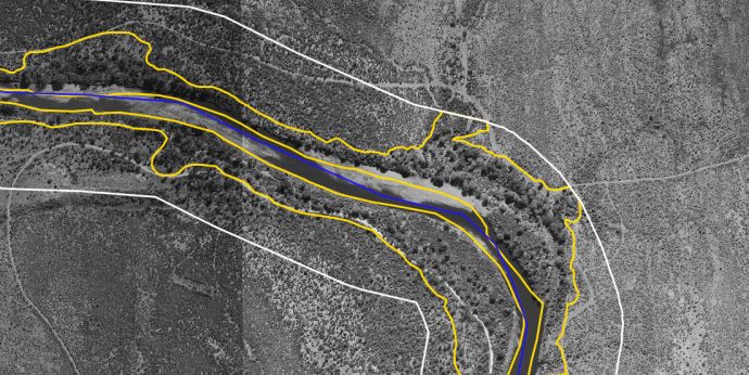
Eighteen sites along 14 of the park’s rivers (nine perennial, five non-perennial) were selected for the study. A multi-decadal time-series analysis of riparian woodland extent was conducted using aerial and satellite imagery, with the oldest photograph used dating back to 1936. Riparian areas were delineated along a 10 km stretch of river at each site and then the tree cover proportion was estimated using random point plots using GIS tools (Figure 2).
|
|
|
The time-series of tree cover at each site was compared to river flow data sourced from Department of Water and Sanitation gauging stations (Figure 3) located at the centre of each site. Rainfall data from the nearest South African Weather Service station to each site was also compared to the tree cover.
Particular attention was paid to cumulative flow effects, as well as the frequency and magnitude of large infrequent disturbances (LIDs) such as droughts and floods, which regulate the depth of the water table and may cause physical disturbance.
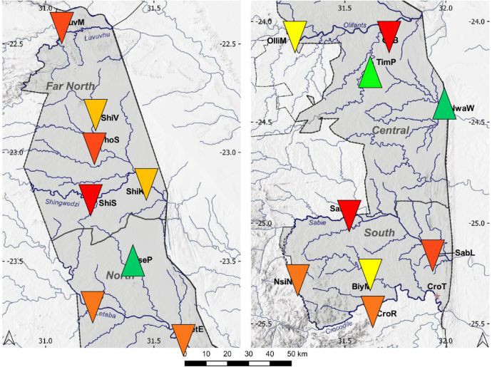
Tree cover typically fluctuated over the time period, with the trajectory of change being variable between sites. Most (14 of 18) sites experienced decreasing overall tree cover between the first and last observation, with these decreases being significant at six sites (red and deep orange arrows, Figure 4).
Several sites were sparsely covered in the 1940s to 1960s, before experiencing increases in woody cover, which has subsequently declined over the last three decades. Tree cover increased only at three sites (green arrows, Figure 4) over time, with these increases being significant in one instance.
Increased riparian woodland cover was associated with non-perennial rivers which have transient surface water only after large flood events. Further, increased tree cover was only seen in rivers where the catchments fall at least 90% within the protected area, highlighting a possible positive link to a lack of anthropogenic disturbance.
|
Peak flow and maximum rainfall events, however, were the strongest significant association with decreases in riparian tree cover, indicating that floods are potentially the biggest drivers of tree loss. Indeed, tree cover decreased substantially at several sites following the mega-flood event of early 2000 (one of the largest on record) and subsequent large floods over the last decade, such as those in 2012 and 2013.
A bleak future for these woodlands?
With predictions of increasing climate variability and extreme climate events into the future, and increasing anthropogenic disturbance, particularly through water abstraction outside of but impacting protected areas, the future of the riparian woodlands of the Lowveld, and of their associated biota, looks bleak.
The findings from this study should prompt increased attention to riparian habitats and fine-scale, detailed work aimed at further understanding the dynamics of these systems. This will go some way in determining thresholds for conservation concern in an attempt to ensure persistence of these important ecosystems, in not only KNP, but other subtropical savannas.